
 Maureville
Samoëns
Gréning
Toulouse
Volx
Goudet
Méhoncourt
Saint-Hymer
Pontcarré
Maureville
Samoëns
Gréning
Toulouse
Volx
Goudet
Méhoncourt
Saint-Hymer
Pontcarré
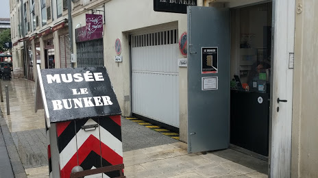
Bunker La Rochelle(Le Bunker de La Rochelle) on the map, La Rochelle, France
Photo
Where is located Bunker La Rochelle(Le Bunker de La Rochelle)
Bunker La Rochelle(Le Bunker de La Rochelle) — local attraction, which is located at 8 Rue des Dames, 17000 La Rochelle, France and belongs to the category — history museum. Average visitor rating for this place — 4.3 (according to 1422 ratings, information from open sources and relevant for 2022).
Exact location — Bunker La Rochelle(Le Bunker de La Rochelle), marked on the map with a red marker.
You can get directions to Bunker La Rochelle(Le Bunker de La Rochelle) on the map from your location.
What else is interesting in La Rochelle? You can see all the sights if you go to the city page.
Coordinates
Bunker La Rochelle(Le Bunker de La Rochelle), France coordinates in decimal format: latitude — 46.16084563699298, longitude — -1.176262954281617. When converted to degrees, minutes, seconds Bunker La Rochelle(Le Bunker de La Rochelle) has the following coordinates: 46°9′39.04 north latitude and -1°10′34.55 east longitude.
Nearby cities
The largest cities that are located nearby:
- Nantes — 121 km
- Angers — 152 km
- Bordeaux — 153 km
- Limoges — 189 km
- Tours — 194 km
- Rennes — 220 km
- Le Mans — 227 km
- Orléans — 298 km
- San Sebastián
 (Spain) — 321 km
 - Clermont-Ferrand — 330 km
- Caen — 339 km
- Brest — 347 km
- Toulouse — 351 km
- Bilbao (Spain) — 351 km
- Santander (Spain) — 367 km
- Pamplona (Spain) — 372 km
- Le Havre — 380 km
- Vitoria-Gasteiz (Spain) — 385 km
- Boulogne-Billancourt — 386 km
Distance to the capital
Distance to the capital (Paris) is about — 400 km.