
 Maureville
Samoëns
Gréning
Toulouse
Volx
Goudet
Méhoncourt
Saint-Hymer
Pontcarré
Maureville
Samoëns
Gréning
Toulouse
Volx
Goudet
Méhoncourt
Saint-Hymer
Pontcarré
Espace Rabelais - Centre oenotouristique du Gard rhodanien on the map, Bagnols-sur-Cèze, France
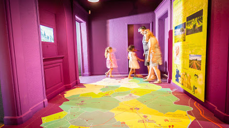
Photo
Where is located Espace Rabelais - Centre oenotouristique du Gard rhodanien
Espace Rabelais - Centre oenotouristique du Gard rhodanien — local attraction, which is located at Pl. Auguste Mallet, 30200 Bagnols-sur-Cèze, France and belongs to the category — museum. Average visitor rating for this place — 4.8 (according to 10 ratings, information from open sources and relevant for 2022).
Exact location — Espace Rabelais - Centre oenotouristique du Gard rhodanien, marked on the map with a red marker.
You can get directions to Espace Rabelais - Centre oenotouristique du Gard rhodanien on the map from your location.
What else is interesting in Bagnols-sur-Cèze? You can see all the sights if you go to the city page.
Coordinates
Espace Rabelais - Centre oenotouristique du Gard rhodanien, France coordinates in decimal format: latitude — 44.16190549618146, longitude — 4.619595197880842. When converted to degrees, minutes, seconds Espace Rabelais - Centre oenotouristique du Gard rhodanien has the following coordinates: 44°9′42.86 north latitude and 4°37′10.54 east longitude.
Nearby cities
The largest cities that are located nearby:
- Nimes — 42 km
- Montpellier — 85 km
- Aix-en-Provence — 96 km
- Marseille — 113 km
- Saint-Étienne — 142 km
- Grenoble — 142 km
- Toulon — 156 km
- Lyon — 178 km
- Villeurbanne — 179 km
- Clermont-Ferrand — 214 km
- Perpignan — 215 km
- Nice — 217 km
- Geneva
 (Switzerland) — 253 km
 - Turin
 (Italy) — 260 km
 - Toulouse — 262 km
- Lausanne (Switzerland) — 302 km
- Limoges — 318 km
- Novara (Italy) — 341 km
- Mataró
 (Spain) — 341 km
Distance to the capital
Distance to the capital (Paris) is about — 550 km.