
 Maureville
Samoëns
Gréning
Toulouse
Volx
Goudet
Méhoncourt
Saint-Hymer
Pontcarré
Maureville
Samoëns
Gréning
Toulouse
Volx
Goudet
Méhoncourt
Saint-Hymer
Pontcarré
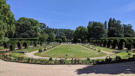
Prés Fichaux Garden on the map, Bourges, France
Photo
Where is located Prés Fichaux Garden
Prés Fichaux Garden — local attraction, which is located at Bd de la République, 18000 Bourges, France and belongs to the category — garden. Average visitor rating for this place — 4.4 (according to 1334 ratings, information from open sources and relevant for 2022).
Exact location — Prés Fichaux Garden, marked on the map with a red marker.
You can get directions to Prés Fichaux Garden on the map from your location.
What else is interesting in Bourges? You can see all the sights if you go to the city page.
Coordinates
Prés Fichaux Garden, France coordinates in decimal format: latitude — 47.09035235583768, longitude — 2.3953950979792036. When converted to degrees, minutes, seconds Prés Fichaux Garden has the following coordinates: 47°5′25.27 north latitude and 2°23′43.42 east longitude.
Nearby cities
The largest cities that are located nearby:
- Orléans — 98 km
- Tours — 133 km
- Clermont-Ferrand — 154 km
- Limoges — 163 km
- Le Mans — 192 km
- Boulogne-Billancourt — 195 km
- Dijon — 200 km
- Angers — 226 km
- Lyon — 238 km
- Saint-Étienne — 238 km
- Villeurbanne — 241 km
- Reims — 268 km
- Besançon — 273 km
- Rouen — 277 km
- Nantes — 297 km
- Geneva
 (Switzerland) — 303 km
 - Caen — 307 km
- Amiens — 311 km
- Le Havre — 313 km
Distance to the capital
Distance to the capital (Paris) is about — 196 km.