
 Maureville
Samoëns
Gréning
Toulouse
Volx
Goudet
Méhoncourt
Saint-Hymer
Pontcarré
Maureville
Samoëns
Gréning
Toulouse
Volx
Goudet
Méhoncourt
Saint-Hymer
Pontcarré
Château de Dinan on the map, Dinan, France
Photo
Where is located Château de Dinan
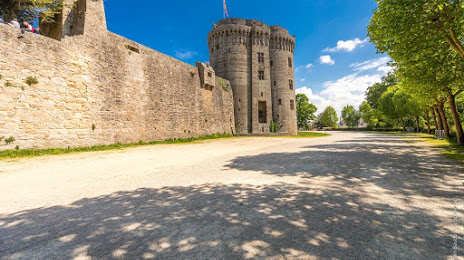
Château de Dinan — local attraction, which is located at Rue du Château, 22100 Dinan, France and belongs to the category — castle. Average visitor rating for this place — 4.4 (according to 523 ratings, information from open sources and relevant for 2022).
Exact location — Château de Dinan, marked on the map with a red marker.
You can get directions to Château de Dinan on the map from your location.
What else is interesting in Dinan? You can see all the sights if you go to the city page.
Coordinates
Château de Dinan, France coordinates in decimal format: latitude — 48.44995197643835, longitude — -2.0447912155233823. When converted to degrees, minutes, seconds Château de Dinan has the following coordinates: 48°26′59.83 north latitude and -2°2′41.25 east longitude.
Nearby cities
The largest cities that are located nearby:
- Rennes — 46 km
- Nantes — 142 km
- Caen — 145 km
- Angers — 155 km
- Le Mans — 173 km
- Brest — 179 km
- Le Havre — 193 km
- Tours — 236 km
- Bournemouth
 (United Kingdom) — 251 km
 - Rouen — 251 km
- Portsmouth (United Kingdom) — 270 km
- Exeter (United Kingdom) — 271 km
- Southampton (United Kingdom) — 275 km
- Orléans — 300 km
- Eastbourne (United Kingdom) — 304 km
- Boulogne-Billancourt — 315 km
- Crawley (United Kingdom) — 321 km
- Bristol (Great Britain) — 334 km
- Reading (United Kingdom) — 340 km
Distance to the capital
Distance to the capital (Paris) is about — 326 km.