
 Maureville
Samoëns
Gréning
Toulouse
Volx
Goudet
Méhoncourt
Saint-Hymer
Pontcarré
Maureville
Samoëns
Gréning
Toulouse
Volx
Goudet
Méhoncourt
Saint-Hymer
Pontcarré
Église Saint-Nicolas on the map, Blois, France
Photo
Where is located Église Saint-Nicolas
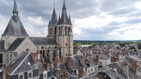
Église Saint-Nicolas — local attraction, which is located at Rue Saint-Laumer, 41000 Blois, France and belongs to the category — catholic church. Average visitor rating for this place — 4.3 (according to 166 ratings, information from open sources and relevant for 2022).
Exact location — Église Saint-Nicolas, marked on the map with a red marker.
You can get directions to Église Saint-Nicolas on the map from your location.
What else is interesting in Blois? You can see all the sights if you go to the city page.
Coordinates
Église Saint-Nicolas, France coordinates in decimal format: latitude — 47.58394189569654, longitude — 1.3309948979962438. When converted to degrees, minutes, seconds Église Saint-Nicolas has the following coordinates: 47°35′2.19 north latitude and 1°19′51.58 east longitude.
Nearby cities
The largest cities that are located nearby:
- Tours — 53 km
- Orléans — 55 km
- Le Mans — 96 km
- Angers — 142 km
- Boulogne-Billancourt — 153 km
- Limoges — 194 km
- Rouen — 206 km
- Caen — 215 km
- Nantes — 221 km
- Le Havre — 229 km
- Rennes — 230 km
- Clermont-Ferrand — 241 km
- Amiens — 264 km
- Reims — 268 km
- Dijon — 279 km
- Saint-Étienne — 335 km
- Lyon — 337 km
- Bordeaux — 339 km
- Villeurbanne — 340 km
Distance to the capital
Distance to the capital (Paris) is about — 161 km.