
 Maureville
Samoëns
Gréning
Toulouse
Volx
Goudet
Méhoncourt
Saint-Hymer
Pontcarré
Maureville
Samoëns
Gréning
Toulouse
Volx
Goudet
Méhoncourt
Saint-Hymer
Pontcarré
Plage de la Baume on the map, Hyères, France
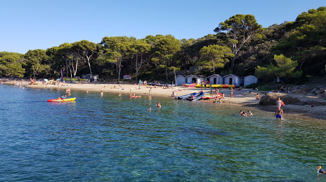
Photo
Where is located Plage de la Baume
Plage de la Baume — local attraction, which is located at 83400 Hyères, France and belongs to the category — tourist attraction. Average visitor rating for this place — 4.2 (according to 174 ratings, information from open sources and relevant for 2022).
Exact location — Plage de la Baume, marked on the map with a red marker.
You can get directions to Plage de la Baume on the map from your location.
What else is interesting in Hyères? You can see all the sights if you go to the city page.
Coordinates
Plage de la Baume, France coordinates in decimal format: latitude — 43.033939567969306, longitude — 6.160660397844287. When converted to degrees, minutes, seconds Plage de la Baume has the following coordinates: 43°2′2.18 north latitude and 6°9′38.38 east longitude.
Nearby cities
The largest cities that are located nearby:
- Toulon — 16 km
- Marseille — 64 km
- Aix-en-Provence — 71 km
- Nice — 112 km
- Nimes — 162 km
- Montpellier — 188 km
- Grenoble — 231 km
- Turin
 (Italy) — 248 km
 - Genoa (Italy) — 264 km
- Perpignan — 267 km
- Saint-Étienne — 290 km
- Villeurbanne — 308 km
- Lyon — 309 km
- Novara (Italy) — 322 km
- Sassari (Italy) — 334 km
- Livorno (Italy) — 338 km
- Geneva
 (Switzerland) — 340 km
 - Milan (Italy) — 351 km
- Mataró
 (Spain) — 352 km
Distance to the capital
Distance to the capital (Paris) is about — 711 km.