
 Maureville
Samoëns
Gréning
Toulouse
Volx
Goudet
Méhoncourt
Saint-Hymer
Pontcarré
Maureville
Samoëns
Gréning
Toulouse
Volx
Goudet
Méhoncourt
Saint-Hymer
Pontcarré
Maladrerie Saint-Lazare de Voisinlieu (Maladrerie Saint-Lazare) on the map, Beauvais, France
Photo
Where is located Maladrerie Saint-Lazare de Voisinlieu (Maladrerie Saint-Lazare)
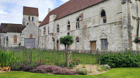
Maladrerie Saint-Lazare de Voisinlieu (Maladrerie Saint-Lazare) — local attraction, which is located at 203 Rue de Paris, 60000 Beauvais, France and belongs to the category — cultural landmark. Average visitor rating for this place — 4.5 (according to 638 ratings, information from open sources and relevant for 2022).
Exact location — Maladrerie Saint-Lazare de Voisinlieu (Maladrerie Saint-Lazare), marked on the map with a red marker.
You can get directions to Maladrerie Saint-Lazare de Voisinlieu (Maladrerie Saint-Lazare) on the map from your location.
What else is interesting in Beauvais? You can see all the sights if you go to the city page.
Coordinates
Maladrerie Saint-Lazare de Voisinlieu (Maladrerie Saint-Lazare), France coordinates in decimal format: latitude — 49.41533608001289, longitude — 2.101306998060691. When converted to degrees, minutes, seconds Maladrerie Saint-Lazare de Voisinlieu (Maladrerie Saint-Lazare) has the following coordinates: 49°24′55.21 north latitude and 2°6′4.71 east longitude.
Nearby cities
The largest cities that are located nearby:
- Amiens — 54 km
- Boulogne-Billancourt — 66 km
- Rouen — 71 km
- Le Havre — 142 km
- Reims — 142 km
- Lille — 149 km
- Orléans — 169 km
- Caen — 179 km
- Eastbourne
 (United Kingdom) — 194 km
 - Charleroi
 (Belgium) — 199 km
 - Le Mans — 210 km
- Brussels (Belgium) — 223 km
- Namur (Belgium) — 228 km
- Gillingham (United Kingdom) — 241 km
- Crawley (United Kingdom) — 243 km
- Tours — 248 km
- Southend-on-Sea (United Kingdom) — 252 km
- Antwerp (Belgium) — 255 km
- Basildon (United Kingdom) — 261 km
Distance to the capital
Distance to the capital (Paris) is about — 65 km.