
 Maureville
Samoëns
Gréning
Toulouse
Volx
Goudet
Méhoncourt
Saint-Hymer
Pontcarré
Maureville
Samoëns
Gréning
Toulouse
Volx
Goudet
Méhoncourt
Saint-Hymer
Pontcarré
Église catholique Saint-Martin à Roubaix on the map, Roubaix, France
Photo
Where is located Église catholique Saint-Martin à Roubaix
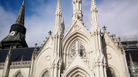
Église catholique Saint-Martin à Roubaix — local attraction, which is located at Contour de l'Église St Martin, 59100 Roubaix, France and belongs to the category — catholic church. Average visitor rating for this place — 4.4 (according to 123 ratings, information from open sources and relevant for 2022).
Exact location — Église catholique Saint-Martin à Roubaix, marked on the map with a red marker.
You can get directions to Église catholique Saint-Martin à Roubaix on the map from your location.
What else is interesting in Roubaix? You can see all the sights if you go to the city page.
Coordinates
Église catholique Saint-Martin à Roubaix, France coordinates in decimal format: latitude — 50.69207169658088, longitude — 3.173868698106684. When converted to degrees, minutes, seconds Église catholique Saint-Martin à Roubaix has the following coordinates: 50°41′31.46 north latitude and 3°10′25.93 east longitude.
Nearby cities
The largest cities that are located nearby:
- Lille — 11 km
- Brussels
 (Belgium) — 84 km
 - Charleroi (Belgium) — 95 km
- Antwerp (Belgium) — 103 km
- Amiens — 108 km
- Namur (Belgium) — 122 km
- Breda
 (Netherlands) — 148 km
 - Dordrecht (Netherlands) — 161 km
- Rotterdam (Netherlands) — 162 km
- Tilburg (Netherlands) — 163 km
- Liège (Belgium) — 169 km
- Reims — 170 km
- The Hague (Netherlands) — 170 km
- Zoetermeer (Netherlands) — 176 km
- Maastricht (Netherlands) — 176 km
- Eindhoven (Netherlands) — 178 km
- 's-Hertogenbosch (Netherlands) — 183 km
- Leiden (Netherlands) — 185 km
- Southend-on-Sea
 (United Kingdom) — 194 km
Distance to the capital
Distance to the capital (Paris) is about — 213 km.