
 Maureville
Samoëns
Gréning
Toulouse
Volx
Goudet
Méhoncourt
Saint-Hymer
Pontcarré
Maureville
Samoëns
Gréning
Toulouse
Volx
Goudet
Méhoncourt
Saint-Hymer
Pontcarré
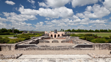
Archaeological Site of Gisacum - The Old-Evreux on the map, Évreux, France
Photo
Where is located Archaeological Site of Gisacum - The Old-Evreux
Archaeological Site of Gisacum - The Old-Evreux — local attraction, which is located at 8 Rue des Thermes, 27930 Le Vieil-Évreux, France and belongs to the category — archaeological museum. Average visitor rating for this place — 4.3 (according to 263 ratings, information from open sources and relevant for 2022).
Exact location — Archaeological Site of Gisacum - The Old-Evreux, marked on the map with a red marker.
You can get directions to Archaeological Site of Gisacum - The Old-Evreux on the map from your location.
What else is interesting in Évreux? You can see all the sights if you go to the city page.
Coordinates
Archaeological Site of Gisacum - The Old-Evreux, France coordinates in decimal format: latitude — 49.002835887570164, longitude — 1.234565798046008. When converted to degrees, minutes, seconds Archaeological Site of Gisacum - The Old-Evreux has the following coordinates: 49°0′10.21 north latitude and 1°14′4.44 east longitude.
Nearby cities
The largest cities that are located nearby:
- Rouen — 46 km
- Boulogne-Billancourt — 82 km
- Le Havre — 91 km
- Caen — 111 km
- Amiens — 126 km
- Le Mans — 133 km
- Orléans — 136 km
- Tours — 184 km
- Eastbourne
 (United Kingdom) — 202 km
 - Reims — 209 km
- Angers — 214 km
- Lille — 222 km
- Rennes — 232 km
- Crawley (United Kingdom) — 248 km
- Portsmouth (United Kingdom) — 252 km
- Gillingham (United Kingdom) — 264 km
- Southampton (United Kingdom) — 274 km
- Sutton (United Kingdom) — 274 km
- Charleroi
 (Belgium) — 278 km
Distance to the capital
Distance to the capital (Paris) is about — 83 km.