
 Maureville
Samoëns
Gréning
Toulouse
Volx
Goudet
Méhoncourt
Saint-Hymer
Pontcarré
Maureville
Samoëns
Gréning
Toulouse
Volx
Goudet
Méhoncourt
Saint-Hymer
Pontcarré
Souterrains de Pontoise on the map, Éragny, France
Photo
Where is located Souterrains de Pontoise
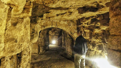
Souterrains de Pontoise — local attraction, which is located at Office de tourisme de Cergy, 95300 Pontoise, France and belongs to the category — museum. Average visitor rating for this place — 4.7 (according to 3 ratings, information from open sources and relevant for 2022).
Exact location — Souterrains de Pontoise, marked on the map with a red marker.
You can get directions to Souterrains de Pontoise on the map from your location.
What else is interesting in Éragny? You can see all the sights if you go to the city page.
Coordinates
Souterrains de Pontoise, France coordinates in decimal format: latitude — 49.046833718675586, longitude — 2.1001206980475566. When converted to degrees, minutes, seconds Souterrains de Pontoise has the following coordinates: 49°2′48.6 north latitude and 2°6′0.43 east longitude.
Nearby cities
The largest cities that are located nearby:
- Boulogne-Billancourt — 23 km
- Rouen — 85 km
- Amiens — 97 km
- Orléans — 125 km
- Reims — 142 km
- Le Havre — 152 km
- Caen — 179 km
- Le Mans — 180 km
- Lille — 190 km
- Tours — 209 km
- Charleroi
 (Belgium) — 226 km
 - Eastbourne
 (United Kingdom) — 230 km
 - Namur (Belgium) — 252 km
- Brussels (Belgium) — 256 km
- Angers — 262 km
- Crawley (United Kingdom) — 280 km
- Gillingham (United Kingdom) — 282 km
- Dijon — 290 km
- Antwerp (Belgium) — 291 km
Distance to the capital
Distance to the capital (Paris) is about — 28 km.