
 Maureville
Samoëns
Gréning
Toulouse
Volx
Goudet
Méhoncourt
Saint-Hymer
Pontcarré
Maureville
Samoëns
Gréning
Toulouse
Volx
Goudet
Méhoncourt
Saint-Hymer
Pontcarré
Pont de Saint-Cloud on the map, Sèvres, France
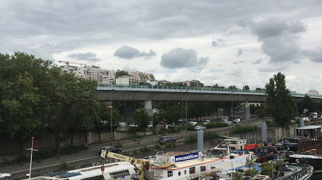
Photo
Where is located Pont de Saint-Cloud
Pont de Saint-Cloud — local attraction, which is located at D1, 92100 Boulogne-Billancourt, France and belongs to the category — bridge. Average visitor rating for this place — 4.4 (according to 5 ratings, information from open sources and relevant for 2022).
Exact location — Pont de Saint-Cloud, marked on the map with a red marker.
You can get directions to Pont de Saint-Cloud on the map from your location.
What else is interesting in Sèvres? You can see all the sights if you go to the city page.
Coordinates
Pont de Saint-Cloud, France coordinates in decimal format: latitude — 48.84120957348255, longitude — 2.223781798040282. When converted to degrees, minutes, seconds Pont de Saint-Cloud has the following coordinates: 48°50′28.35 north latitude and 2°13′25.61 east longitude.
Nearby cities
The largest cities that are located nearby:
- Boulogne-Billancourt — 3 km
- Orléans — 104 km
- Rouen — 105 km
- Amiens — 119 km
- Reims — 140 km
- Le Havre — 168 km
- Le Mans — 174 km
- Caen — 191 km
- Tours — 195 km
- Lille — 209 km
- Charleroi
 (Belgium) — 236 km
 - Eastbourne
 (United Kingdom) — 254 km
 - Angers — 255 km
- Namur (Belgium) — 261 km
- Dijon — 269 km
- Brussels (Belgium) — 270 km
- Metz — 289 km
- Nancy — 290 km
- Rennes — 297 km
Distance to the capital
Distance to the capital (Paris) is about — 10 km.