
 Maureville
Samoëns
Gréning
Toulouse
Volx
Goudet
Méhoncourt
Saint-Hymer
Pontcarré
Maureville
Samoëns
Gréning
Toulouse
Volx
Goudet
Méhoncourt
Saint-Hymer
Pontcarré
Trocadéro Garden on the map, Sèvres, France
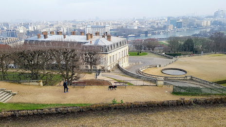
Photo
Where is located Trocadéro Garden
Trocadéro Garden — local attraction, which is located at 92210 Saint-Cloud, France and belongs to the category — garden. Average visitor rating for this place — 4.9 (according to 14 ratings, information from open sources and relevant for 2022).
Exact location — Trocadéro Garden, marked on the map with a red marker.
You can get directions to Trocadéro Garden on the map from your location.
What else is interesting in Sèvres? You can see all the sights if you go to the city page.
Coordinates
Trocadéro Garden, France coordinates in decimal format: latitude — 48.839185072055265, longitude — 2.21437949804022. When converted to degrees, minutes, seconds Trocadéro Garden has the following coordinates: 48°50′21.07 north latitude and 2°12′51.77 east longitude.
Nearby cities
The largest cities that are located nearby:
- Boulogne-Billancourt — 3 km
- Orléans — 104 km
- Rouen — 105 km
- Amiens — 119 km
- Reims — 140 km
- Le Havre — 168 km
- Le Mans — 174 km
- Caen — 191 km
- Tours — 195 km
- Lille — 209 km
- Charleroi
 (Belgium) — 236 km
 - Eastbourne
 (United Kingdom) — 254 km
 - Angers — 255 km
- Namur (Belgium) — 261 km
- Dijon — 269 km
- Brussels (Belgium) — 270 km
- Metz — 289 km
- Nancy — 290 km
- Rennes — 297 km
Distance to the capital
Distance to the capital (Paris) is about — 10 km.