
 Maureville
Samoëns
Gréning
Toulouse
Volx
Goudet
Méhoncourt
Saint-Hymer
Pontcarré
Maureville
Samoëns
Gréning
Toulouse
Volx
Goudet
Méhoncourt
Saint-Hymer
Pontcarré
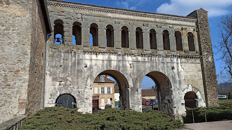
Porte Saint-André on the map, Autun, France
Photo
Where is located Porte Saint-André
Porte Saint-André — local attraction, which is located at Rue de la Croix Blanche, 71400 Autun, France and belongs to the category — historical landmark. Average visitor rating for this place — 4.2 (according to 136 ratings, information from open sources and relevant for 2022).
Exact location — Porte Saint-André, marked on the map with a red marker.
You can get directions to Porte Saint-André on the map from your location.
What else is interesting in Autun? You can see all the sights if you go to the city page.
Coordinates
Porte Saint-André, France coordinates in decimal format: latitude — 46.957739364989536, longitude — 4.306071997974607. When converted to degrees, minutes, seconds Porte Saint-André has the following coordinates: 46°57′27.86 north latitude and 4°18′21.86 east longitude.
Nearby cities
The largest cities that are located nearby:
- Dijon — 69 km
- Besançon — 133 km
- Lyon — 138 km
- Villeurbanne — 138 km
- Clermont-Ferrand — 160 km
- Geneva
 (Switzerland) — 164 km
 - Saint-Étienne — 167 km
- Lausanne (Switzerland) — 184 km
- Orléans — 206 km
- Grenoble — 224 km
- Nancy — 237 km
- Bern (Switzerland) — 237 km
- Mulhouse — 242 km
- Basel (Switzerland) — 255 km
- Reims — 256 km
- Boulogne-Billancourt — 257 km
- Limoges — 265 km
- Tours — 275 km
- Metz — 275 km
Distance to the capital
Distance to the capital (Paris) is about — 257 km.