
 Maureville
Samoëns
Gréning
Toulouse
Volx
Goudet
Méhoncourt
Saint-Hymer
Pontcarré
Maureville
Samoëns
Gréning
Toulouse
Volx
Goudet
Méhoncourt
Saint-Hymer
Pontcarré
Institut du monde arabe-Tourcoing on the map, Tourcoing, France
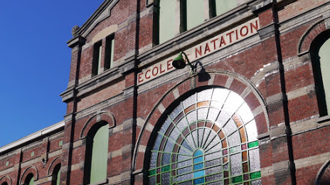
Photo
Where is located Institut du monde arabe-Tourcoing
Institut du monde arabe-Tourcoing — local attraction, which is located at 9 Rue Gabriel Péri, 59200 Tourcoing, France and belongs to the category — cultural association. Average visitor rating for this place — 4.0 (according to 149 ratings, information from open sources and relevant for 2022).
Exact location — Institut du monde arabe-Tourcoing, marked on the map with a red marker.
You can get directions to Institut du monde arabe-Tourcoing on the map from your location.
What else is interesting in Tourcoing? You can see all the sights if you go to the city page.
Coordinates
Institut du monde arabe-Tourcoing, France coordinates in decimal format: latitude — 50.725186420580805, longitude — 3.1584057981078812. When converted to degrees, minutes, seconds Institut du monde arabe-Tourcoing has the following coordinates: 50°43′30.67 north latitude and 3°9′30.26 east longitude.
Nearby cities
The largest cities that are located nearby:
- Lille — 13 km
- Brussels
 (Belgium) — 84 km
 - Charleroi (Belgium) — 97 km
- Antwerp (Belgium) — 102 km
- Amiens — 111 km
- Namur (Belgium) — 124 km
- Breda
 (Netherlands) — 146 km
 - Dordrecht (Netherlands) — 159 km
- Rotterdam (Netherlands) — 160 km
- Tilburg (Netherlands) — 162 km
- The Hague (Netherlands) — 168 km
- Liège (Belgium) — 170 km
- Zoetermeer (Netherlands) — 173 km
- Reims — 174 km
- Maastricht (Netherlands) — 177 km
- Eindhoven (Netherlands) — 178 km
- 's-Hertogenbosch (Netherlands) — 182 km
- Leiden (Netherlands) — 183 km
- Southend-on-Sea
 (United Kingdom) — 192 km
Distance to the capital
Distance to the capital (Paris) is about — 216 km.