
 Maureville
Samoëns
Gréning
Toulouse
Volx
Goudet
Méhoncourt
Saint-Hymer
Pontcarré
Maureville
Samoëns
Gréning
Toulouse
Volx
Goudet
Méhoncourt
Saint-Hymer
Pontcarré
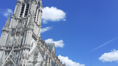
Église Saint-Christophe on the map, Tourcoing, France
Photo
Where is located Église Saint-Christophe
Église Saint-Christophe — local attraction, which is located at Parvis Saint Christophe, 59200 Tourcoing, France and belongs to the category — catholic church. Average visitor rating for this place — 4.4 (according to 242 ratings, information from open sources and relevant for 2022).
Exact location — Église Saint-Christophe, marked on the map with a red marker.
You can get directions to Église Saint-Christophe on the map from your location.
What else is interesting in Tourcoing? You can see all the sights if you go to the city page.
Coordinates
Église Saint-Christophe, France coordinates in decimal format: latitude — 50.72194611823192, longitude — 3.159545998107767. When converted to degrees, minutes, seconds Église Saint-Christophe has the following coordinates: 50°43′19.01 north latitude and 3°9′34.37 east longitude.
Nearby cities
The largest cities that are located nearby:
- Lille — 13 km
- Brussels
 (Belgium) — 84 km
 - Charleroi (Belgium) — 97 km
- Antwerp (Belgium) — 102 km
- Amiens — 111 km
- Namur (Belgium) — 124 km
- Breda
 (Netherlands) — 146 km
 - Dordrecht (Netherlands) — 159 km
- Rotterdam (Netherlands) — 160 km
- Tilburg (Netherlands) — 162 km
- The Hague (Netherlands) — 168 km
- Liège (Belgium) — 170 km
- Zoetermeer (Netherlands) — 173 km
- Reims — 174 km
- Maastricht (Netherlands) — 177 km
- Eindhoven (Netherlands) — 178 km
- 's-Hertogenbosch (Netherlands) — 182 km
- Leiden (Netherlands) — 183 km
- Southend-on-Sea
 (United Kingdom) — 192 km
Distance to the capital
Distance to the capital (Paris) is about — 215 km.