
 Maureville
Samoëns
Gréning
Toulouse
Volx
Goudet
Méhoncourt
Saint-Hymer
Pontcarré
Maureville
Samoëns
Gréning
Toulouse
Volx
Goudet
Méhoncourt
Saint-Hymer
Pontcarré
Château Mme de Graffigny on the map, Laxou, France
Photo
Where is located Château Mme de Graffigny
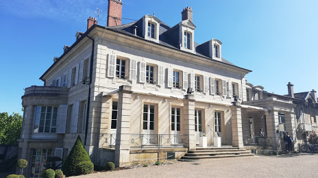
Château Mme de Graffigny — local attraction, which is located at Rue Albert 1er, 54600 Villers-lès-Nancy, France and belongs to the category — castle. Average visitor rating for this place — 4.4 (according to 398 ratings, information from open sources and relevant for 2022).
Exact location — Château Mme de Graffigny, marked on the map with a red marker.
You can get directions to Château Mme de Graffigny on the map from your location.
What else is interesting in Laxou? You can see all the sights if you go to the city page.
Coordinates
Château Mme de Graffigny, France coordinates in decimal format: latitude — 48.67016085305067, longitude — 6.145993598034241. When converted to degrees, minutes, seconds Château Mme de Graffigny has the following coordinates: 48°40′12.58 north latitude and 6°8′45.58 east longitude.
Nearby cities
The largest cities that are located nearby:
- Nancy — 2 km
- Metz — 48 km
- Saarbrücken
 (Germany) — 87 km
 - Strasbourg — 118 km
- Trier (Germany) — 123 km
- Mulhouse — 136 km
- Freiburg (Germany) — 146 km
- Besançon — 160 km
- Basel
 (Switzerland) — 164 km
 - Reims — 166 km
- Karlsruhe (Germany) — 167 km
- Dijon — 172 km
- Pforzheim (Germany) — 186 km
- Ludwigshafen (Germany) — 187 km
- Mannheim (Germany) — 188 km
- Heidelberg (Germany) — 198 km
- Mainz (Germany) — 208 km
- Koblenz (Germany) — 211 km
- Wiesbaden (Germany) — 214 km
Distance to the capital
Distance to the capital (Paris) is about — 279 km.