
 Maureville
Samoëns
Gréning
Toulouse
Volx
Goudet
Méhoncourt
Saint-Hymer
Pontcarré
Maureville
Samoëns
Gréning
Toulouse
Volx
Goudet
Méhoncourt
Saint-Hymer
Pontcarré
Church of St. Anthony of Padua on the map, Montigny-le-Bretonneux, France
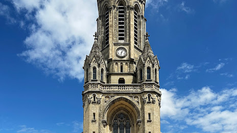
Photo
Where is located Church of St. Anthony of Padua
Church of St. Anthony of Padua — local attraction, which is located at 3 Pl. Saint-Antoine de Padoue, 78150 Le Chesnay-Rocquencourt, France and belongs to the category — catholic church. Average visitor rating for this place — 4.6 (according to 126 ratings, information from open sources and relevant for 2022).
Exact location — Church of St. Anthony of Padua, marked on the map with a red marker.
You can get directions to Church of St. Anthony of Padua on the map from your location.
What else is interesting in Montigny-le-Bretonneux? You can see all the sights if you go to the city page.
Coordinates
Church of St. Anthony of Padua, France coordinates in decimal format: latitude — 48.81839335739987, longitude — 2.130776298039492. When converted to degrees, minutes, seconds Church of St. Anthony of Padua has the following coordinates: 48°49′6.22 north latitude and 2°7′50.79 east longitude.
Nearby cities
The largest cities that are located nearby:
- Boulogne-Billancourt — 17 km
- Orléans — 97 km
- Rouen — 100 km
- Amiens — 125 km
- Reims — 154 km
- Le Havre — 160 km
- Le Mans — 160 km
- Caen — 180 km
- Tours — 183 km
- Lille — 217 km
- Angers — 241 km
- Charleroi
 (Belgium) — 248 km
 - Eastbourne
 (United Kingdom) — 252 km
 - Namur (Belgium) — 274 km
- Dijon — 277 km
- Brussels (Belgium) — 281 km
- Rennes — 284 km
- Crawley (United Kingdom) — 301 km
- Metz — 302 km
Distance to the capital
Distance to the capital (Paris) is about — 17 km.