
 Maureville
Samoëns
Gréning
Toulouse
Volx
Goudet
Méhoncourt
Saint-Hymer
Pontcarré
Maureville
Samoëns
Gréning
Toulouse
Volx
Goudet
Méhoncourt
Saint-Hymer
Pontcarré
Centre historique du monde sapeur pompier on the map, Thiers, France
Photo
Where is located Centre historique du monde sapeur pompier
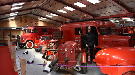
Centre historique du monde sapeur pompier — local attraction, which is located at 17 rue du pré de la pie, felet, 63300 Thiers, France and belongs to the category — museum. Average visitor rating for this place — 4.8 (according to 29 ratings, information from open sources and relevant for 2022).
Exact location — Centre historique du monde sapeur pompier, marked on the map with a red marker.
You can get directions to Centre historique du monde sapeur pompier on the map from your location.
What else is interesting in Thiers? You can see all the sights if you go to the city page.
Coordinates
Centre historique du monde sapeur pompier, France coordinates in decimal format: latitude — 45.85210841526196, longitude — 3.5078352979370164. When converted to degrees, minutes, seconds Centre historique du monde sapeur pompier has the following coordinates: 45°51′7.59 north latitude and 3°30′28.21 east longitude.
Nearby cities
The largest cities that are located nearby:
- Clermont-Ferrand — 36 km
- Saint-Étienne — 80 km
- Lyon — 100 km
- Villeurbanne — 104 km
- Limoges — 176 km
- Grenoble — 185 km
- Dijon — 197 km
- Geneva
 (Switzerland) — 202 km
 - Nimes — 233 km
- Besançon — 241 km
- Lausanne (Switzerland) — 246 km
- Montpellier — 250 km
- Orléans — 257 km
- Tours — 273 km
- Aix-en-Provence — 299 km
- Toulouse — 301 km
- Bern (Switzerland) — 318 km
- Marseille — 319 km
- Turin
 (Italy) — 335 km
Distance to the capital
Distance to the capital (Paris) is about — 345 km.