
 Maureville
Samoëns
Gréning
Toulouse
Volx
Goudet
Méhoncourt
Saint-Hymer
Pontcarré
Maureville
Samoëns
Gréning
Toulouse
Volx
Goudet
Méhoncourt
Saint-Hymer
Pontcarré
Lac Bleu on the map, Arras, France
Photo
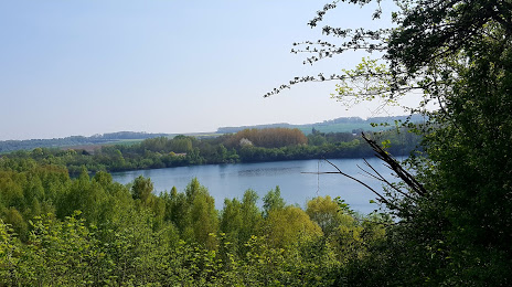
Where is located Lac Bleu
Lac Bleu — local attraction, which is located at no data and belongs to the category — -. Average visitor rating for this place — 3.4 (according to 40 ratings, information from open sources and relevant for 2022).
Exact location — Lac Bleu, marked on the map with a red marker.
You can get directions to Lac Bleu on the map from your location.
What else is interesting in Arras? You can see all the sights if you go to the city page.
Coordinates
Lac Bleu, France coordinates in decimal format: latitude — 50.29853443340572, longitude — 2.915060042750559. When converted to degrees, minutes, seconds Lac Bleu has the following coordinates: 50°17′54.72 north latitude and 2°54′54.22 east longitude.
Nearby cities
The largest cities that are located nearby:
- Lille — 42 km
- Amiens — 56 km
- Charleroi
 (Belgium) — 118 km
 - Brussels (Belgium) — 126 km
- Reims — 146 km
- Namur (Belgium) — 149 km
- Antwerp (Belgium) — 152 km
- Rouen — 153 km
- Boulogne-Billancourt — 165 km
- Eastbourne
 (United Kingdom) — 182 km
 - Gillingham (United Kingdom) — 196 km
- Breda
 (Netherlands) — 198 km
 - Southend-on-Sea (United Kingdom) — 199 km
- Liège (Belgium) — 200 km
- Le Havre — 211 km
- Basildon (United Kingdom) — 212 km
- Tilburg (Netherlands) — 212 km
- Maastricht (Netherlands) — 213 km
- Dordrecht (Netherlands) — 213 km
Distance to the capital
Distance to the capital (Paris) is about — 165 km.