
 Maureville
Samoëns
Gréning
Toulouse
Volx
Goudet
Méhoncourt
Saint-Hymer
Pontcarré
Maureville
Samoëns
Gréning
Toulouse
Volx
Goudet
Méhoncourt
Saint-Hymer
Pontcarré
Eglise Saint-Cyr Sainte-Julitte - Paroisse Saint-Jean-XXIII on the map, Ivry-sur-Seine, France
Photo
Where is located Eglise Saint-Cyr Sainte-Julitte - Paroisse Saint-Jean-XXIII
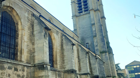
Eglise Saint-Cyr Sainte-Julitte - Paroisse Saint-Jean-XXIII — local attraction, which is located at Pl. de la Mairie, 94800 Villejuif, France and belongs to the category — catholic church. Average visitor rating for this place — 4.2 (according to 66 ratings, information from open sources and relevant for 2022).
Exact location — Eglise Saint-Cyr Sainte-Julitte - Paroisse Saint-Jean-XXIII, marked on the map with a red marker.
You can get directions to Eglise Saint-Cyr Sainte-Julitte - Paroisse Saint-Jean-XXIII on the map from your location.
What else is interesting in Ivry-sur-Seine? You can see all the sights if you go to the city page.
Coordinates
Eglise Saint-Cyr Sainte-Julitte - Paroisse Saint-Jean-XXIII, France coordinates in decimal format: latitude — 48.79208403886179, longitude — 2.3635514980385515. When converted to degrees, minutes, seconds Eglise Saint-Cyr Sainte-Julitte - Paroisse Saint-Jean-XXIII has the following coordinates: 48°47′31.5 north latitude and 2°21′48.79 east longitude.
Nearby cities
The largest cities that are located nearby:
- Boulogne-Billancourt — 11 km
- Orléans — 107 km
- Rouen — 116 km
- Amiens — 120 km
- Reims — 128 km
- Le Havre — 180 km
- Le Mans — 185 km
- Tours — 202 km
- Caen — 204 km
- Lille — 206 km
- Charleroi
 (Belgium) — 228 km
 - Namur (Belgium) — 253 km
- Dijon — 258 km
- Eastbourne
 (United Kingdom) — 261 km
 - Brussels (Belgium) — 264 km
- Angers — 265 km
- Metz — 276 km
- Nancy — 277 km
- Antwerp (Belgium) — 300 km
Distance to the capital
Distance to the capital (Paris) is about — 7 km.