
 Maureville
Samoëns
Gréning
Toulouse
Volx
Goudet
Méhoncourt
Saint-Hymer
Pontcarré
Maureville
Samoëns
Gréning
Toulouse
Volx
Goudet
Méhoncourt
Saint-Hymer
Pontcarré
Lac d'Enghien on the map, Argenteuil, France
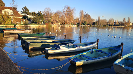
Photo
Where is located Lac d'Enghien
Lac d'Enghien — local attraction, which is located at 43 ha and belongs to the category — -. Average visitor rating for this place — 4.5 (according to 240 ratings, information from open sources and relevant for 2022).
Exact location — Lac d'Enghien, marked on the map with a red marker.
You can get directions to Lac d'Enghien on the map from your location.
What else is interesting in Argenteuil? You can see all the sights if you go to the city page.
Coordinates
Lac d'Enghien, France coordinates in decimal format: latitude — 48.97094298869325, longitude — 2.2986764425603363. When converted to degrees, minutes, seconds Lac d'Enghien has the following coordinates: 48°58′15.39 north latitude and 2°17′55.24 east longitude.
Nearby cities
The largest cities that are located nearby:
- Boulogne-Billancourt — 12 km
- Rouen — 99 km
- Amiens — 105 km
- Orléans — 118 km
- Reims — 133 km
- Le Havre — 165 km
- Le Mans — 184 km
- Caen — 191 km
- Lille — 194 km
- Tours — 208 km
- Charleroi
 (Belgium) — 224 km
 - Eastbourne
 (United Kingdom) — 243 km
 - Namur (Belgium) — 250 km
- Brussels (Belgium) — 257 km
- Angers — 265 km
- Dijon — 276 km
- Metz — 285 km
- Nancy — 289 km
- Antwerp (Belgium) — 292 km
Distance to the capital
Distance to the capital (Paris) is about — 13 km.