
 Maureville
Samoëns
Gréning
Toulouse
Volx
Goudet
Méhoncourt
Saint-Hymer
Pontcarré
Maureville
Samoëns
Gréning
Toulouse
Volx
Goudet
Méhoncourt
Saint-Hymer
Pontcarré
Palais du Roi de Rome on the map, Rambouillet, France
Photo
Where is located Palais du Roi de Rome
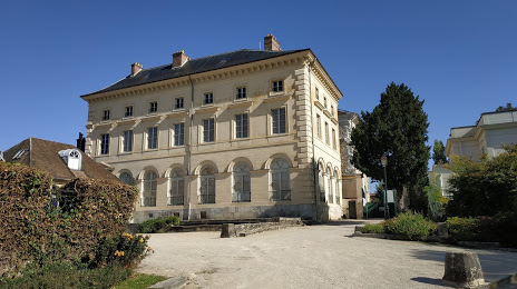
Palais du Roi de Rome — local attraction, which is located at Pl. du Roi de Rome, 78120 Rambouillet, France and belongs to the category — cultural landmark. Average visitor rating for this place — 4.4 (according to 20 ratings, information from open sources and relevant for 2022).
Exact location — Palais du Roi de Rome, marked on the map with a red marker.
You can get directions to Palais du Roi de Rome on the map from your location.
What else is interesting in Rambouillet? You can see all the sights if you go to the city page.
Coordinates
Palais du Roi de Rome, France coordinates in decimal format: latitude — 48.645118935445566, longitude — 1.822660198033353. When converted to degrees, minutes, seconds Palais du Roi de Rome has the following coordinates: 48°38′42.43 north latitude and 1°49′21.58 east longitude.
Nearby cities
The largest cities that are located nearby:
- Boulogne-Billancourt — 37 km
- Orléans — 82 km
- Rouen — 103 km
- Le Mans — 140 km
- Amiens — 142 km
- Le Havre — 155 km
- Tours — 163 km
- Caen — 170 km
- Reims — 173 km
- Angers — 220 km
- Lille — 236 km
- Eastbourne
 (United Kingdom) — 258 km
 - Rennes — 265 km
- Charleroi
 (Belgium) — 269 km
 - Dijon — 282 km
- Namur (Belgium) — 294 km
- Nantes — 299 km
- Brussels (Belgium) — 301 km
- Crawley (United Kingdom) — 306 km
Distance to the capital
Distance to the capital (Paris) is about — 45 km.