
 Maureville
Samoëns
Gréning
Toulouse
Volx
Goudet
Méhoncourt
Saint-Hymer
Pontcarré
Maureville
Samoëns
Gréning
Toulouse
Volx
Goudet
Méhoncourt
Saint-Hymer
Pontcarré
Sausset State Park on the map, Gonesse, France
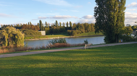
Photo
Where is located Sausset State Park
Sausset State Park — local attraction, which is located at Parc Départemental du Sausset, Route Camille Pissaro, 93420 Villepinte, France and belongs to the category — park. Average visitor rating for this place — 4.4 (according to 2624 ratings, information from open sources and relevant for 2022).
Exact location — Sausset State Park, marked on the map with a red marker.
You can get directions to Sausset State Park on the map from your location.
What else is interesting in Gonesse? You can see all the sights if you go to the city page.
Coordinates
Sausset State Park, France coordinates in decimal format: latitude — 49.00963869237818, longitude — 2.547965998046269. When converted to degrees, minutes, seconds Sausset State Park has the following coordinates: 49°0′34.7 north latitude and 2°32′52.68 east longitude.
Nearby cities
The largest cities that are located nearby:
- Boulogne-Billancourt — 22 km
- Amiens — 101 km
- Rouen — 109 km
- Reims — 118 km
- Orléans — 126 km
- Le Havre — 177 km
- Lille — 187 km
- Le Mans — 199 km
- Caen — 205 km
- Charleroi
 (Belgium) — 211 km
 - Tours — 220 km
- Namur (Belgium) — 236 km
- Brussels (Belgium) — 245 km
- Eastbourne
 (United Kingdom) — 248 km
 - Dijon — 268 km
- Metz — 270 km
- Nancy — 275 km
- Angers — 280 km
- Antwerp (Belgium) — 281 km
Distance to the capital
Distance to the capital (Paris) is about — 22 km.