
 Maureville
Samoëns
Gréning
Toulouse
Volx
Goudet
Méhoncourt
Saint-Hymer
Pontcarré
Maureville
Samoëns
Gréning
Toulouse
Volx
Goudet
Méhoncourt
Saint-Hymer
Pontcarré
Château de Champs-sur-Marne on the map, Chelles, France
Photo
Where is located Château de Champs-sur-Marne
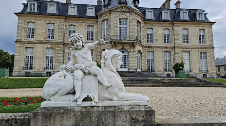
Château de Champs-sur-Marne — local attraction, which is located at 31 Rue de Paris, 77420 Champs-sur-Marne, France and belongs to the category — castle. Average visitor rating for this place — 4.5 (according to 1602 ratings, information from open sources and relevant for 2022).
Exact location — Château de Champs-sur-Marne, marked on the map with a red marker.
You can get directions to Château de Champs-sur-Marne on the map from your location.
What else is interesting in Chelles? You can see all the sights if you go to the city page.
Coordinates
Château de Champs-sur-Marne, France coordinates in decimal format: latitude — 48.84821976812703, longitude — 2.594031435380621. When converted to degrees, minutes, seconds Château de Champs-sur-Marne has the following coordinates: 48°50′53.59 north latitude and 2°35′38.51 east longitude.
Nearby cities
The largest cities that are located nearby:
- Boulogne-Billancourt — 26 km
- Reims — 112 km
- Amiens — 114 km
- Orléans — 119 km
- Rouen — 124 km
- Le Havre — 191 km
- Lille — 196 km
- Le Mans — 201 km
- Charleroi
 (Belgium) — 214 km
 - Caen — 217 km
- Tours — 217 km
- Namur (Belgium) — 238 km
- Brussels (Belgium) — 250 km
- Dijon — 252 km
- Metz — 261 km
- Nancy — 263 km
- Eastbourne
 (United Kingdom) — 264 km
 - Angers — 282 km
- Liège (Belgium) — 286 km
Distance to the capital
Distance to the capital (Paris) is about — 18 km.