
 Maureville
Samoëns
Gréning
Toulouse
Volx
Goudet
Méhoncourt
Saint-Hymer
Pontcarré
Maureville
Samoëns
Gréning
Toulouse
Volx
Goudet
Méhoncourt
Saint-Hymer
Pontcarré
Ruines du Moulin de Chelles on the map, Chelles, France
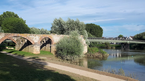
Photo
Where is located Ruines du Moulin de Chelles
Ruines du Moulin de Chelles — local attraction, which is located at 3 Quai Auguste Prévost, 77500 Chelles, France and belongs to the category — historical landmark. Average visitor rating for this place — 4.3 (according to 554 ratings, information from open sources and relevant for 2022).
Exact location — Ruines du Moulin de Chelles, marked on the map with a red marker.
You can get directions to Ruines du Moulin de Chelles on the map from your location.
What else is interesting in Chelles? You can see all the sights if you go to the city page.
Coordinates
Ruines du Moulin de Chelles, France coordinates in decimal format: latitude — 48.86547519059302, longitude — 2.58708179804115. When converted to degrees, minutes, seconds Ruines du Moulin de Chelles has the following coordinates: 48°51′55.71 north latitude and 2°35′13.49 east longitude.
Nearby cities
The largest cities that are located nearby:
- Boulogne-Billancourt — 26 km
- Reims — 112 km
- Amiens — 114 km
- Orléans — 119 km
- Rouen — 124 km
- Le Havre — 191 km
- Lille — 196 km
- Le Mans — 201 km
- Charleroi
 (Belgium) — 214 km
 - Caen — 217 km
- Tours — 217 km
- Namur (Belgium) — 238 km
- Brussels (Belgium) — 250 km
- Dijon — 252 km
- Metz — 261 km
- Nancy — 263 km
- Eastbourne
 (United Kingdom) — 264 km
 - Angers — 282 km
- Liège (Belgium) — 286 km
Distance to the capital
Distance to the capital (Paris) is about — 17 km.