
 Maureville
Samoëns
Gréning
Toulouse
Volx
Goudet
Méhoncourt
Saint-Hymer
Pontcarré
Maureville
Samoëns
Gréning
Toulouse
Volx
Goudet
Méhoncourt
Saint-Hymer
Pontcarré
Évêché Lisieux Garden on the map, Lisieux, France
Photo
Where is located Évêché Lisieux Garden
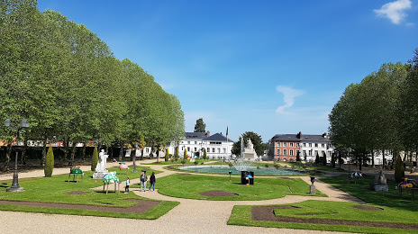
Évêché Lisieux Garden — local attraction, which is located at 12 Rue Jacques de Condorcet, 14100 Lisieux, France and belongs to the category — botanical garden. Average visitor rating for this place — 4.3 (according to 766 ratings, information from open sources and relevant for 2022).
Exact location — évêché Lisieux Garden, marked on the map with a red marker.
You can get directions to Évêché Lisieux Garden on the map from your location.
What else is interesting in Lisieux? You can see all the sights if you go to the city page.
Coordinates
évêché Lisieux Garden, France coordinates in decimal format: latitude — 49.147484389911554, longitude — 0.22602249805113317. When converted to degrees, minutes, seconds évêché Lisieux Garden has the following coordinates: 49°8′50.94 north latitude and 0°13′33.68 east longitude.
Nearby cities
The largest cities that are located nearby:
- Le Havre — 39 km
- Caen — 43 km
- Rouen — 71 km
- Le Mans — 126 km
- Boulogne-Billancourt — 150 km
- Amiens — 169 km
- Eastbourne
 (United Kingdom) — 179 km
 - Rennes — 181 km
- Orléans — 186 km
- Angers — 194 km
- Tours — 197 km
- Portsmouth (United Kingdom) — 207 km
- Crawley (United Kingdom) — 219 km
- Southampton (United Kingdom) — 226 km
- Bournemouth (United Kingdom) — 228 km
- Sutton (United Kingdom) — 247 km
- Gillingham (United Kingdom) — 249 km
- Nantes — 252 km
- Lille — 257 km
Distance to the capital
Distance to the capital (Paris) is about — 158 km.