
 Maureville
Samoëns
Gréning
Toulouse
Volx
Goudet
Méhoncourt
Saint-Hymer
Pontcarré
Maureville
Samoëns
Gréning
Toulouse
Volx
Goudet
Méhoncourt
Saint-Hymer
Pontcarré
Bois-Préau Park on the map, Chatou, France
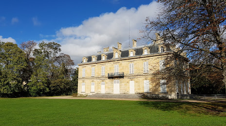
Photo
Where is located Bois-Préau Park
Bois-Préau Park — local attraction, which is located at 2 Rue Charles Floquet, 92500 Rueil-Malmaison, France and belongs to the category — city park. Average visitor rating for this place — 4.5 (according to 403 ratings, information from open sources and relevant for 2022).
Exact location — Bois-Préau Park, marked on the map with a red marker.
You can get directions to Bois-Préau Park on the map from your location.
What else is interesting in Chatou? You can see all the sights if you go to the city page.
Coordinates
Bois-Préau Park, France coordinates in decimal format: latitude — 48.87226299538042, longitude — 2.173100898041371. When converted to degrees, minutes, seconds Bois-Préau Park has the following coordinates: 48°52′20.15 north latitude and 2°10′23.16 east longitude.
Nearby cities
The largest cities that are located nearby:
- Boulogne-Billancourt — 9 km
- Rouen — 97 km
- Amiens — 111 km
- Orléans — 111 km
- Reims — 141 km
- Le Havre — 162 km
- Le Mans — 175 km
- Caen — 186 km
- Tours — 199 km
- Lille — 202 km
- Charleroi
 (Belgium) — 232 km
 - Eastbourne
 (United Kingdom) — 245 km
 - Angers — 257 km
- Namur (Belgium) — 258 km
- Brussels (Belgium) — 265 km
- Dijon — 277 km
- Metz — 292 km
- Crawley (United Kingdom) — 294 km
- Nancy — 295 km
Distance to the capital
Distance to the capital (Paris) is about — 13 km.