
 Maureville
Samoëns
Gréning
Toulouse
Volx
Goudet
Méhoncourt
Saint-Hymer
Pontcarré
Maureville
Samoëns
Gréning
Toulouse
Volx
Goudet
Méhoncourt
Saint-Hymer
Pontcarré
Donjon d'Ambleny on the map, Soissons, France
Photo
Where is located Donjon d'Ambleny
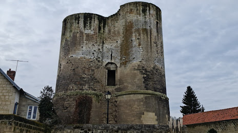
Donjon d'Ambleny — local attraction, which is located at 11 Rue de la Tour, 02290 Ambleny, France and belongs to the category — monument. Average visitor rating for this place — 4.5 (according to 22 ratings, information from open sources and relevant for 2022).
Exact location — Donjon d'Ambleny, marked on the map with a red marker.
You can get directions to Donjon d'Ambleny on the map from your location.
What else is interesting in Soissons? You can see all the sights if you go to the city page.
Coordinates
Donjon d'Ambleny, France coordinates in decimal format: latitude — 49.38056695529316, longitude — 3.1836415980594386. When converted to degrees, minutes, seconds Donjon d'Ambleny has the following coordinates: 49°22′50.04 north latitude and 3°11′1.11 east longitude.
Nearby cities
The largest cities that are located nearby:
- Reims — 53 km
- Amiens — 93 km
- Boulogne-Billancourt — 99 km
- Charleroi
 (Belgium) — 139 km
 - Lille — 140 km
- Rouen — 160 km
- Namur (Belgium) — 163 km
- Brussels (Belgium) — 178 km
- Orléans — 194 km
- Metz — 208 km
- Liège (Belgium) — 211 km
- Antwerp (Belgium) — 217 km
- Nancy — 222 km
- Le Havre — 231 km
- Maastricht
 (Netherlands) — 232 km
 - Trier
 (Germany) — 240 km
 - Aachen (Germany) — 247 km
- Dijon — 261 km
- Eastbourne
 (United Kingdom) — 262 km
Distance to the capital
Distance to the capital (Paris) is about — 84 km.