
 Maureville
Samoëns
Gréning
Toulouse
Volx
Goudet
Méhoncourt
Saint-Hymer
Pontcarré
Maureville
Samoëns
Gréning
Toulouse
Volx
Goudet
Méhoncourt
Saint-Hymer
Pontcarré
Abbatiale du Breuil-Benoit on the map, Dreux, France
Photo
Where is located Abbatiale du Breuil-Benoit
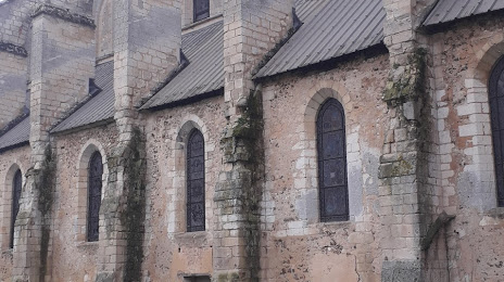
Abbatiale du Breuil-Benoit — local attraction, which is located at Le Breuil Benoît, 27810 Marcilly-sur-Eure, France and belongs to the category — abbey. Average visitor rating for this place — 5.0 (according to 4 ratings, information from open sources and relevant for 2022).
Exact location — Abbatiale du Breuil-Benoit, marked on the map with a red marker.
You can get directions to Abbatiale du Breuil-Benoit on the map from your location.
What else is interesting in Dreux? You can see all the sights if you go to the city page.
Coordinates
Abbatiale du Breuil-Benoit, France coordinates in decimal format: latitude — 48.80894745074312, longitude — 1.355512698039138. When converted to degrees, minutes, seconds Abbatiale du Breuil-Benoit has the following coordinates: 48°48′32.21 north latitude and 1°21′19.85 east longitude.
Nearby cities
The largest cities that are located nearby:
- Boulogne-Billancourt — 64 km
- Rouen — 81 km
- Orléans — 100 km
- Le Mans — 118 km
- Le Havre — 124 km
- Caen — 135 km
- Amiens — 144 km
- Tours — 157 km
- Reims — 201 km
- Angers — 201 km
- Rennes — 235 km
- Eastbourne
 (United Kingdom) — 237 km
 - Lille — 240 km
- Nantes — 276 km
- Crawley (United Kingdom) — 284 km
- Charleroi
 (Belgium) — 285 km
 - Portsmouth (United Kingdom) — 287 km
- Gillingham (United Kingdom) — 298 km
- Southampton (United Kingdom) — 309 km
Distance to the capital
Distance to the capital (Paris) is about — 73 km.