
 Maureville
Samoëns
Gréning
Toulouse
Volx
Goudet
Méhoncourt
Saint-Hymer
Pontcarré
Maureville
Samoëns
Gréning
Toulouse
Volx
Goudet
Méhoncourt
Saint-Hymer
Pontcarré
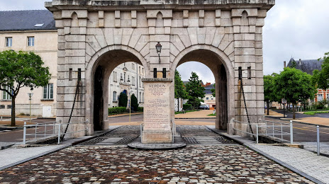
Porte Saint Paul on the map, Verdun, France
Photo
Where is located Porte Saint Paul
Porte Saint Paul — local attraction, which is located at Pl. Saint-Paul, 55100 Verdun, France and belongs to the category — historical landmark. Average visitor rating for this place — 3.8 (according to 38 ratings, information from open sources and relevant for 2022).
Exact location — Porte Saint Paul, marked on the map with a red marker.
You can get directions to Porte Saint Paul on the map from your location.
What else is interesting in Verdun? You can see all the sights if you go to the city page.
Coordinates
Porte Saint Paul, France coordinates in decimal format: latitude — 49.163951501576626, longitude — 5.384746398051725. When converted to degrees, minutes, seconds Porte Saint Paul has the following coordinates: 49°9′50.23 north latitude and 5°23′5.09 east longitude.
Nearby cities
The largest cities that are located nearby:
- Metz — 57 km
- Nancy — 78 km
- Reims — 98 km
- Trier
 (Germany) — 111 km
 - Saarbrücken (Germany) — 117 km
- Namur
 (Belgium) — 149 km
 - Charleroi (Belgium) — 153 km
- Liège (Belgium) — 163 km
- Strasbourg — 185 km
- Aachen (Germany) — 185 km
- Maastricht
 (Netherlands) — 188 km
 - Brussels (Belgium) — 200 km
- Koblenz (Germany) — 204 km
- Dijon — 205 km
- Bonn (Germany) — 212 km
- Mulhouse — 213 km
- Besançon — 218 km
- Karlsruhe (Germany) — 220 km
- Freiburg (Germany) — 223 km
Distance to the capital
Distance to the capital (Paris) is about — 224 km.