
 Maureville
Samoëns
Gréning
Toulouse
Volx
Goudet
Méhoncourt
Saint-Hymer
Pontcarré
Maureville
Samoëns
Gréning
Toulouse
Volx
Goudet
Méhoncourt
Saint-Hymer
Pontcarré
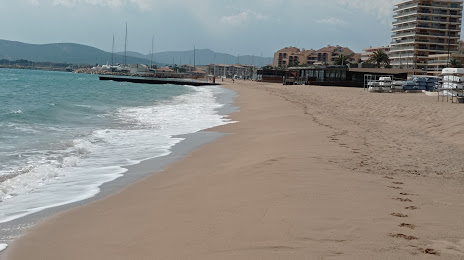
Plage de Fréjus on the map, Fréjus, France
Photo
Where is located Plage de Fréjus
Plage de Fréjus — local attraction, which is located at no data and belongs to the category — -. Average visitor rating for this place — 4.3 (according to 2603 ratings, information from open sources and relevant for 2022).
Exact location — Plage de Fréjus, marked on the map with a red marker.
You can get directions to Plage de Fréjus on the map from your location.
What else is interesting in Fréjus? You can see all the sights if you go to the city page.
Coordinates
Plage de Fréjus, France coordinates in decimal format: latitude — 43.42256306834035, longitude — 6.756452367994957. When converted to degrees, minutes, seconds Plage de Fréjus has the following coordinates: 43°25′21.23 north latitude and 6°45′23.23 east longitude.
Nearby cities
The largest cities that are located nearby:
- Nice — 52 km
- Toulon — 74 km
- Aix-en-Provence — 104 km
- Marseille — 111 km
- Nimes — 195 km
- Turin
 (Italy) — 196 km
 - Genoa (Italy) — 205 km
- Grenoble — 209 km
- Montpellier — 230 km
- Novara (Italy) — 266 km
- Livorno (Italy) — 287 km
- Saint-Étienne — 287 km
- Milan (Italy) — 294 km
- Villeurbanne — 295 km
- Lyon — 297 km
- Monza (Italy) — 308 km
- Geneva
 (Switzerland) — 309 km
 - Parma (Italy) — 320 km
- Perpignan — 323 km
Distance to the capital
Distance to the capital (Paris) is about — 693 km.