
 Maureville
Samoëns
Gréning
Toulouse
Volx
Goudet
Méhoncourt
Saint-Hymer
Pontcarré
Maureville
Samoëns
Gréning
Toulouse
Volx
Goudet
Méhoncourt
Saint-Hymer
Pontcarré
Plages de Sainte-Maxime on the map, Fréjus, France
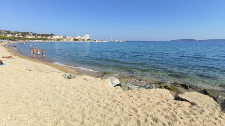
Photo
Where is located Plages de Sainte-Maxime
Plages de Sainte-Maxime — local attraction, which is located at no data and belongs to the category — -. Average visitor rating for this place — 4.4 (according to 34 ratings, information from open sources and relevant for 2022).
Exact location — Plages de Sainte-Maxime, marked on the map with a red marker.
You can get directions to Plages de Sainte-Maxime on the map from your location.
What else is interesting in Fréjus? You can see all the sights if you go to the city page.
Coordinates
Plages de Sainte-Maxime, France coordinates in decimal format: latitude — 43.31331544692568, longitude — 6.672164647853256. When converted to degrees, minutes, seconds Plages de Sainte-Maxime has the following coordinates: 43°18′47.94 north latitude and 6°40′19.79 east longitude.
Nearby cities
The largest cities that are located nearby:
- Nice — 52 km
- Toulon — 74 km
- Aix-en-Provence — 104 km
- Marseille — 111 km
- Nimes — 195 km
- Turin
 (Italy) — 196 km
 - Genoa (Italy) — 205 km
- Grenoble — 209 km
- Montpellier — 230 km
- Novara (Italy) — 266 km
- Livorno (Italy) — 287 km
- Saint-Étienne — 287 km
- Milan (Italy) — 294 km
- Villeurbanne — 295 km
- Lyon — 297 km
- Monza (Italy) — 308 km
- Geneva
 (Switzerland) — 309 km
 - Parma (Italy) — 320 km
- Perpignan — 323 km
Distance to the capital
Distance to the capital (Paris) is about — 701 km.