
 Maureville
Samoëns
Gréning
Toulouse
Volx
Goudet
Méhoncourt
Saint-Hymer
Pontcarré
Maureville
Samoëns
Gréning
Toulouse
Volx
Goudet
Méhoncourt
Saint-Hymer
Pontcarré
Beach Port Galice on the map, Villeneuve-Loubet, France
Photo
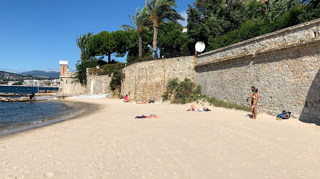
Where is located Beach Port Galice
Beach Port Galice — local attraction, which is located at no data and belongs to the category — -. Average visitor rating for this place — 4.1 (according to 288 ratings, information from open sources and relevant for 2022).
Exact location — Beach Port Galice, marked on the map with a red marker.
You can get directions to Beach Port Galice on the map from your location.
What else is interesting in Villeneuve-Loubet? You can see all the sights if you go to the city page.
Coordinates
Beach Port Galice, France coordinates in decimal format: latitude — 43.55414860740582, longitude — 7.123798268063226. When converted to degrees, minutes, seconds Beach Port Galice has the following coordinates: 43°33′14.93 north latitude and 7°7′25.67 east longitude.
Nearby cities
The largest cities that are located nearby:
- Nice — 13 km
- Toulon — 113 km
- Aix-en-Provence — 135 km
- Marseille — 147 km
- Turin
 (Italy) — 162 km
 - Genoa (Italy) — 166 km
- Grenoble — 201 km
- Nimes — 221 km
- Novara (Italy) — 229 km
- Livorno (Italy) — 256 km
- Milan (Italy) — 256 km
- Montpellier — 260 km
- Monza (Italy) — 270 km
- Parma (Italy) — 281 km
- Saint-Étienne — 290 km
- Villeurbanne — 290 km
- Geneva
 (Switzerland) — 291 km
 - Lyon — 292 km
- Bergamo (Italy) — 300 km
Distance to the capital
Distance to the capital (Paris) is about — 694 km.