
 Maureville
Samoëns
Gréning
Toulouse
Volx
Goudet
Méhoncourt
Saint-Hymer
Pontcarré
Maureville
Samoëns
Gréning
Toulouse
Volx
Goudet
Méhoncourt
Saint-Hymer
Pontcarré
Château de Clairvaux on the map, Châtellerault, France
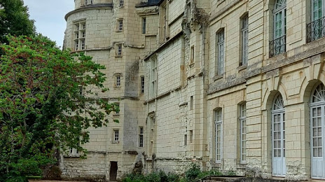
Photo
Where is located Château de Clairvaux
Château de Clairvaux — local attraction, which is located at 86140 Scorbé-Clairvaux, France and belongs to the category — castle. Average visitor rating for this place — 4.2 (according to 29 ratings, information from open sources and relevant for 2022).
Exact location — Château de Clairvaux, marked on the map with a red marker.
You can get directions to Château de Clairvaux on the map from your location.
What else is interesting in Châtellerault? You can see all the sights if you go to the city page.
Coordinates
Château de Clairvaux, France coordinates in decimal format: latitude — 46.80744126226367, longitude — 0.4128765979694439. When converted to degrees, minutes, seconds Château de Clairvaux has the following coordinates: 46°48′26.79 north latitude and 0°24′46.36 east longitude.
Nearby cities
The largest cities that are located nearby:
- Tours — 65 km
- Angers — 111 km
- Limoges — 122 km
- Le Mans — 134 km
- Orléans — 157 km
- Nantes — 164 km
- Rennes — 218 km
- Clermont-Ferrand — 227 km
- Bordeaux — 236 km
- Boulogne-Billancourt — 255 km
- Caen — 270 km
- Rouen — 293 km
- Le Havre — 298 km
- Saint-Étienne — 334 km
- Dijon — 341 km
- Lyon — 351 km
- Villeurbanne — 354 km
- Toulouse — 362 km
- Amiens — 362 km
Distance to the capital
Distance to the capital (Paris) is about — 270 km.