
 Maureville
Samoëns
Gréning
Toulouse
Volx
Goudet
Méhoncourt
Saint-Hymer
Pontcarré
Maureville
Samoëns
Gréning
Toulouse
Volx
Goudet
Méhoncourt
Saint-Hymer
Pontcarré
Tour du Brotsch on the map, Saverne, France
Photo
Where is located Tour du Brotsch
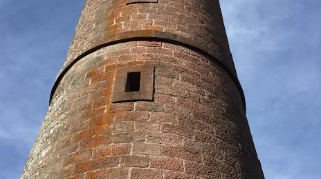
Tour du Brotsch — local attraction, which is located at 67700 Haegen, France and belongs to the category — historical landmark. Average visitor rating for this place — 4.7 (according to 130 ratings, information from open sources and relevant for 2022).
Exact location — Tour du Brotsch, marked on the map with a red marker.
You can get directions to Tour du Brotsch on the map from your location.
What else is interesting in Saverne? You can see all the sights if you go to the city page.
Coordinates
Tour du Brotsch, France coordinates in decimal format: latitude — 48.70675957879251, longitude — 7.324837998035542. When converted to degrees, minutes, seconds Tour du Brotsch has the following coordinates: 48°42′24.33 north latitude and 7°19′29.42 east longitude.
Nearby cities
The largest cities that are located nearby:
- Strasbourg — 34 km
- Saarbrücken
 (Germany) — 61 km
 - Karlsruhe (Germany) — 81 km
- Nancy — 86 km
- Freiburg (Germany) — 90 km
- Metz — 95 km
- Pforzheim (Germany) — 98 km
- Mulhouse — 110 km
- Ludwigshafen (Germany) — 113 km
- Mannheim (Germany) — 114 km
- Heidelberg (Germany) — 119 km
- Trier (Germany) — 123 km
- Basel
 (Switzerland) — 131 km
 - Stuttgart (Germany) — 133 km
- Reutlingen (Germany) — 137 km
- Heilbronn (Germany) — 141 km
- Mainz (Germany) — 152 km
- Darmstadt (Germany) — 155 km
- Wiesbaden (Germany) — 160 km
Distance to the capital
Distance to the capital (Paris) is about — 365 km.