
 Maureville
Samoëns
Gréning
Toulouse
Volx
Goudet
Méhoncourt
Saint-Hymer
Pontcarré
Maureville
Samoëns
Gréning
Toulouse
Volx
Goudet
Méhoncourt
Saint-Hymer
Pontcarré
Champagne Paul-Etienne Saint Germain on the map, Épernay, France
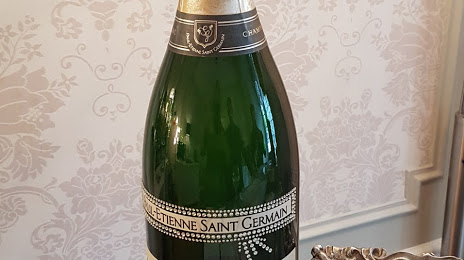
Photo
Where is located Champagne Paul-Etienne Saint Germain
Champagne Paul-Etienne Saint Germain — local attraction, which is located at 51 Av. de Champagne, 51200 Épernay, France and belongs to the category — winery. Average visitor rating for this place — 4.8 (according to 64 ratings, information from open sources and relevant for 2022).
Exact location — Champagne Paul-Etienne Saint Germain, marked on the map with a red marker.
You can get directions to Champagne Paul-Etienne Saint Germain on the map from your location.
What else is interesting in Épernay? You can see all the sights if you go to the city page.
Coordinates
Champagne Paul-Etienne Saint Germain, France coordinates in decimal format: latitude — 49.041639315002236, longitude — 3.9685806980473695. When converted to degrees, minutes, seconds Champagne Paul-Etienne Saint Germain has the following coordinates: 49°2′29.9 north latitude and 3°58′6.89 east longitude.
Nearby cities
The largest cities that are located nearby:
- Reims — 24 km
- Boulogne-Billancourt — 127 km
- Amiens — 151 km
- Charleroi
 (Belgium) — 155 km
 - Metz — 161 km
- Nancy — 167 km
- Namur (Belgium) — 170 km
- Lille — 186 km
- Orléans — 197 km
- Brussels (Belgium) — 202 km
- Trier
 (Germany) — 207 km
 - Dijon — 207 km
- Liège (Belgium) — 209 km
- Rouen — 210 km
- Saarbrücken (Germany) — 221 km
- Maastricht
 (Netherlands) — 234 km
 - Aachen (Germany) — 242 km
- Antwerp (Belgium) — 243 km
- Besançon — 253 km
Distance to the capital
Distance to the capital (Paris) is about — 120 km.