
 Maureville
Samoëns
Gréning
Toulouse
Volx
Goudet
Méhoncourt
Saint-Hymer
Pontcarré
Maureville
Samoëns
Gréning
Toulouse
Volx
Goudet
Méhoncourt
Saint-Hymer
Pontcarré
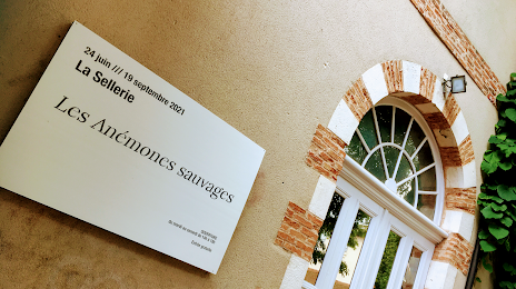
La sellerie du jardin des Carmes on the map, Aurillac, France
Photo
Where is located La sellerie du jardin des Carmes
La sellerie du jardin des Carmes — local attraction, which is located at 37 Rue des Carmes, 15000 Aurillac, France and belongs to the category — garden. Average visitor rating for this place — 4.1 (according to 203 ratings, information from open sources and relevant for 2022).
Exact location — La sellerie du jardin des Carmes, marked on the map with a red marker.
You can get directions to La sellerie du jardin des Carmes on the map from your location.
What else is interesting in Aurillac? You can see all the sights if you go to the city page.
Coordinates
La sellerie du jardin des Carmes, France coordinates in decimal format: latitude — 44.925128497412366, longitude — 2.443560897905983. When converted to degrees, minutes, seconds La sellerie du jardin des Carmes has the following coordinates: 44°55′30.46 north latitude and 2°26′36.82 east longitude.
Nearby cities
The largest cities that are located nearby:
- Clermont-Ferrand — 106 km
- Limoges — 135 km
- Saint-Étienne — 161 km
- Toulouse — 167 km
- Montpellier — 186 km
- Nimes — 195 km
- Lyon — 206 km
- Villeurbanne — 210 km
- Bordeaux — 237 km
- Perpignan — 251 km
- Grenoble — 257 km
- Aix-en-Provence — 286 km
- Marseille — 297 km
- Tours — 303 km
- Geneva
 (Switzerland) — 316 km
 - Dijon — 328 km
- Orléans — 331 km
- Toulon — 345 km
- Angers — 360 km
Distance to the capital
Distance to the capital (Paris) is about — 437 km.