
 Maureville
Samoëns
Gréning
Toulouse
Volx
Goudet
Méhoncourt
Saint-Hymer
Pontcarré
Maureville
Samoëns
Gréning
Toulouse
Volx
Goudet
Méhoncourt
Saint-Hymer
Pontcarré
Les souterrains de Provins on the map, Provins, France
Photo
Where is located Les souterrains de Provins
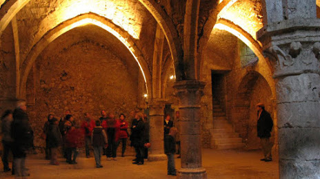
Les souterrains de Provins — local attraction, which is located at 3 Rue Saint-Thibault, 77160 Provins, France and belongs to the category — historical landmark. Average visitor rating for this place — 4.4 (according to 400 ratings, information from open sources and relevant for 2022).
Exact location — Les souterrains de Provins, marked on the map with a red marker.
You can get directions to Les souterrains de Provins on the map from your location.
What else is interesting in Provins? You can see all the sights if you go to the city page.
Coordinates
Les souterrains de Provins, France coordinates in decimal format: latitude — 48.56119017649161, longitude — 3.2949451980304016. When converted to degrees, minutes, seconds Les souterrains de Provins has the following coordinates: 48°33′40.28 north latitude and 3°17′41.8 east longitude.
Nearby cities
The largest cities that are located nearby:
- Boulogne-Billancourt — 83 km
- Reims — 94 km
- Orléans — 126 km
- Amiens — 164 km
- Rouen — 186 km
- Dijon — 189 km
- Nancy — 211 km
- Metz — 217 km
- Charleroi
 (Belgium) — 220 km
 - Lille — 229 km
- Tours — 234 km
- Le Mans — 237 km
- Namur (Belgium) — 238 km
- Le Havre — 251 km
- Besançon — 251 km
- Brussels (Belgium) — 264 km
- Trier
 (Germany) — 272 km
 - Caen — 274 km
- Saarbrücken (Germany) — 277 km
Distance to the capital
Distance to the capital (Paris) is about — 77 km.