
 Maureville
Samoëns
Gréning
Toulouse
Volx
Goudet
Méhoncourt
Saint-Hymer
Pontcarré
Maureville
Samoëns
Gréning
Toulouse
Volx
Goudet
Méhoncourt
Saint-Hymer
Pontcarré
Prieuré Saint-Ayoul on the map, Provins, France
Photo
Where is located Prieuré Saint-Ayoul
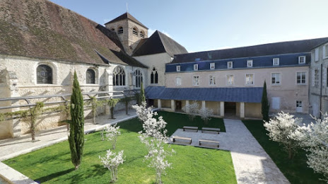
Prieuré Saint-Ayoul — local attraction, which is located at 1 Cr des Bénédictins, 77160 Provins, France and belongs to the category — religious destination. Average visitor rating for this place — 4.7 (according to 17 ratings, information from open sources and relevant for 2022).
Exact location — Prieuré Saint-Ayoul, marked on the map with a red marker.
You can get directions to Prieuré Saint-Ayoul on the map from your location.
What else is interesting in Provins? You can see all the sights if you go to the city page.
Coordinates
Prieuré Saint-Ayoul, France coordinates in decimal format: latitude — 48.56044547596872, longitude — 3.302821098030386. When converted to degrees, minutes, seconds Prieuré Saint-Ayoul has the following coordinates: 48°33′37.6 north latitude and 3°18′10.16 east longitude.
Nearby cities
The largest cities that are located nearby:
- Boulogne-Billancourt — 83 km
- Reims — 94 km
- Orléans — 126 km
- Amiens — 164 km
- Rouen — 186 km
- Dijon — 189 km
- Nancy — 211 km
- Metz — 217 km
- Charleroi
 (Belgium) — 220 km
 - Lille — 229 km
- Tours — 234 km
- Le Mans — 237 km
- Namur (Belgium) — 238 km
- Le Havre — 251 km
- Besançon — 251 km
- Brussels (Belgium) — 264 km
- Trier
 (Germany) — 272 km
 - Caen — 274 km
- Saarbrücken (Germany) — 277 km
Distance to the capital
Distance to the capital (Paris) is about — 77 km.