
 Maureville
Samoëns
Gréning
Toulouse
Volx
Goudet
Méhoncourt
Saint-Hymer
Pontcarré
Maureville
Samoëns
Gréning
Toulouse
Volx
Goudet
Méhoncourt
Saint-Hymer
Pontcarré
Église Saint-Pierre de Naves on the map, Tulle, France
Photo
Where is located Église Saint-Pierre de Naves
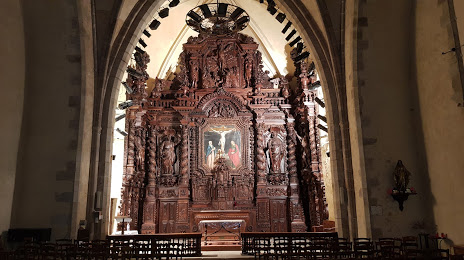
Église Saint-Pierre de Naves — local attraction, which is located at 1 Pl. de l'Église, 19460 Naves, France and belongs to the category — catholic church. Average visitor rating for this place — 4.5 (according to 32 ratings, information from open sources and relevant for 2022).
Exact location — Église Saint-Pierre de Naves, marked on the map with a red marker.
You can get directions to Église Saint-Pierre de Naves on the map from your location.
What else is interesting in Tulle? You can see all the sights if you go to the city page.
Coordinates
Église Saint-Pierre de Naves, France coordinates in decimal format: latitude — 45.31284675463088, longitude — 1.7674193979189163. When converted to degrees, minutes, seconds Église Saint-Pierre de Naves has the following coordinates: 45°18′46.25 north latitude and 1°46′2.71 east longitude.
Nearby cities
The largest cities that are located nearby:
- Limoges — 74 km
- Clermont-Ferrand — 116 km
- Toulouse — 186 km
- Bordeaux — 190 km
- Saint-Étienne — 204 km
- Lyon — 243 km
- Villeurbanne — 247 km
- Montpellier — 249 km
- Tours — 249 km
- Nimes — 260 km
- Orléans — 292 km
- Perpignan — 299 km
- Angers — 300 km
- Grenoble — 308 km
- Le Mans — 325 km
- Nantes — 330 km
- Dijon — 334 km
- Geneva
 (Switzerland) — 350 km
 - Aix-en-Provence — 352 km
Distance to the capital
Distance to the capital (Paris) is about — 397 km.