
 Maureville
Samoëns
Gréning
Toulouse
Volx
Goudet
Méhoncourt
Saint-Hymer
Pontcarré
Maureville
Samoëns
Gréning
Toulouse
Volx
Goudet
Méhoncourt
Saint-Hymer
Pontcarré
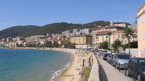
Plage Saint-Francois on the map, Ajaccio, France
Photo
Where is located Plage Saint-Francois
Plage Saint-Francois — local attraction, which is located at no data and belongs to the category — -. Average visitor rating for this place — 4.2 (according to 35 ratings, information from open sources and relevant for 2022).
Exact location — Plage Saint-Francois, marked on the map with a red marker.
You can get directions to Plage Saint-Francois on the map from your location.
What else is interesting in Ajaccio? You can see all the sights if you go to the city page.
Coordinates
Plage Saint-Francois, France coordinates in decimal format: latitude — 41.91677026173728, longitude — 8.736819397808823. When converted to degrees, minutes, seconds Plage Saint-Francois has the following coordinates: 41°55′0.37 north latitude and 8°44′12.55 east longitude.
Nearby cities
The largest cities that are located nearby:
- Sassari
 (Italy) — 133 km
 - Livorno (Italy) — 220 km
- Nice — 231 km
- Toulon — 263 km
- Genoa (Italy) — 275 km
- Florence (Italy) — 287 km
- Prato (Italy) — 287 km
- Cagliari (Italy) — 300 km
- Rome (Italy) — 309 km
- Marseille — 311 km
- Aix-en-Provence — 318 km
- Perugia (Italy) — 323 km
- Terni (Italy) — 326 km
- Parma (Italy) — 342 km
- Modena (Italy) — 347 km
- Latina (Italy) — 349 km
- Bologna (Italy) — 351 km
- Turin (Italy) — 358 km
- Forli (Italy) — 365 km
Distance to the capital
Distance to the capital (Paris) is about — 918 km.