
 Maureville
Samoëns
Gréning
Toulouse
Volx
Goudet
Méhoncourt
Saint-Hymer
Pontcarré
Maureville
Samoëns
Gréning
Toulouse
Volx
Goudet
Méhoncourt
Saint-Hymer
Pontcarré
Usine élévatoire de Trilbardou on the map, Meaux, France
Photo
Where is located Usine élévatoire de Trilbardou
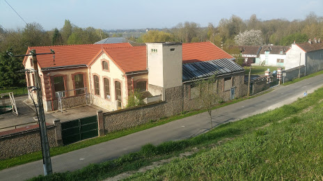
Usine élévatoire de Trilbardou — local attraction, which is located at 77450 Trilbardou, France and belongs to the category — museum. Average visitor rating for this place — 4.3 (according to 42 ratings, information from open sources and relevant for 2022).
Exact location — Usine élévatoire de Trilbardou, marked on the map with a red marker.
You can get directions to Usine élévatoire de Trilbardou on the map from your location.
What else is interesting in Meaux? You can see all the sights if you go to the city page.
Coordinates
Usine élévatoire de Trilbardou, France coordinates in decimal format: latitude — 48.94852084919923, longitude — 2.797475998044069. When converted to degrees, minutes, seconds Usine élévatoire de Trilbardou has the following coordinates: 48°56′54.68 north latitude and 2°47′50.91 east longitude.
Nearby cities
The largest cities that are located nearby:
- Boulogne-Billancourt — 49 km
- Reims — 89 km
- Amiens — 112 km
- Orléans — 137 km
- Rouen — 139 km
- Lille — 185 km
- Charleroi
 (Belgium) — 195 km
 - Le Havre — 208 km
- Namur (Belgium) — 218 km
- Le Mans — 225 km
- Brussels (Belgium) — 233 km
- Caen — 237 km
- Metz — 239 km
- Tours — 239 km
- Dijon — 242 km
- Nancy — 242 km
- Liège (Belgium) — 265 km
- Eastbourne
 (United Kingdom) — 270 km
 - Antwerp (Belgium) — 271 km
Distance to the capital
Distance to the capital (Paris) is about — 34 km.