
 Maureville
Samoëns
Gréning
Toulouse
Volx
Goudet
Méhoncourt
Saint-Hymer
Pontcarré
Maureville
Samoëns
Gréning
Toulouse
Volx
Goudet
Méhoncourt
Saint-Hymer
Pontcarré
Saint Peter's church, Vienne on the map, Vienne, France
Photo
Where is located Saint Peter's church, Vienne
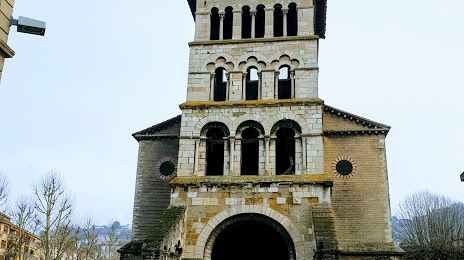
Saint Peter's church, Vienne — local attraction, which is located at Pl. Saint-Pierre, 38200 Vienne, France and belongs to the category — local history museum. Average visitor rating for this place — 4.5 (according to 34 ratings, information from open sources and relevant for 2022).
Exact location — Saint Peter's church, Vienne, marked on the map with a red marker.
You can get directions to Saint Peter's church, Vienne on the map from your location.
What else is interesting in Vienne? You can see all the sights if you go to the city page.
Coordinates
Saint Peter's church, Vienne, France coordinates in decimal format: latitude — 45.52286229468224, longitude — 4.870876497925951. When converted to degrees, minutes, seconds Saint Peter's church, Vienne has the following coordinates: 45°31′22.3 north latitude and 4°52′15.16 east longitude.
Nearby cities
The largest cities that are located nearby:
- Lyon — 27 km
- Villeurbanne — 27 km
- Saint-Étienne — 39 km
- Grenoble — 76 km
- Geneva
 (Switzerland) — 122 km
 - Clermont-Ferrand — 141 km
- Lausanne (Switzerland) — 173 km
- Nimes — 191 km
- Dijon — 199 km
- Besançon — 208 km
- Turin
 (Italy) — 225 km
 - Aix-en-Provence — 225 km
- Montpellier — 226 km
- Marseille — 250 km
- Bern (Switzerland) — 250 km
- Nice — 277 km
- Toulon — 279 km
- Limoges — 280 km
- Novara (Italy) — 291 km
Distance to the capital
Distance to the capital (Paris) is about — 417 km.