
 Maureville
Samoëns
Gréning
Toulouse
Volx
Goudet
Méhoncourt
Saint-Hymer
Pontcarré
Maureville
Samoëns
Gréning
Toulouse
Volx
Goudet
Méhoncourt
Saint-Hymer
Pontcarré
Château de Montcornet on the map, Charleville-Mézières, France
Photo
Where is located Château de Montcornet
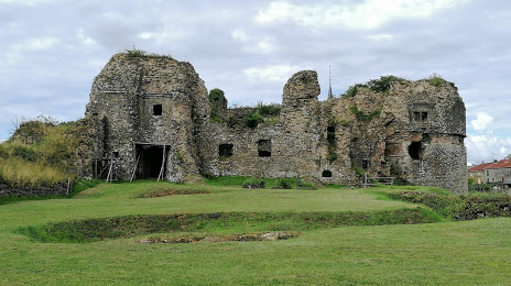
Château de Montcornet — local attraction, which is located at en Ardenne, 11 Place Terre Cadet, 08090 Montcornet, France and belongs to the category — historical landmark. Average visitor rating for this place — 4.4 (according to 176 ratings, information from open sources and relevant for 2022).
Exact location — Château de Montcornet, marked on the map with a red marker.
You can get directions to Château de Montcornet on the map from your location.
What else is interesting in Charleville-Mézières? You can see all the sights if you go to the city page.
Coordinates
Château de Montcornet, France coordinates in decimal format: latitude — 49.830161815995176, longitude — 4.627551498233945. When converted to degrees, minutes, seconds Château de Montcornet has the following coordinates: 49°49′48.58 north latitude and 4°37′39.19 east longitude.
Nearby cities
The largest cities that are located nearby:
- Charleroi
 (Belgium) — 74 km
 - Reims — 75 km
- Namur (Belgium) — 79 km
- Liège (Belgium) — 113 km
- Brussels (Belgium) — 123 km
- Metz — 127 km
- Trier
 (Germany) — 137 km
 - Maastricht
 (Netherlands) — 138 km
 - Aachen (Germany) — 147 km
- Lille — 151 km
- Nancy — 159 km
- Antwerp (Belgium) — 163 km
- Amiens — 174 km
- Saarbrücken (Germany) — 174 km
- Eindhoven (Netherlands) — 193 km
- Mönchengladbach (Germany) — 197 km
- Bonn (Germany) — 198 km
- Tilburg (Netherlands) — 200 km
- Breda (Netherlands) — 201 km
Distance to the capital
Distance to the capital (Paris) is about — 197 km.