
 Maureville
Samoëns
Gréning
Toulouse
Volx
Goudet
Méhoncourt
Saint-Hymer
Pontcarré
Maureville
Samoëns
Gréning
Toulouse
Volx
Goudet
Méhoncourt
Saint-Hymer
Pontcarré
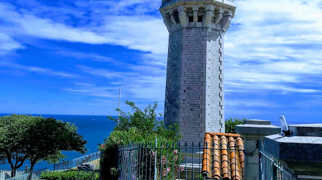
Phare du Mont-Saint-Clair, Sète on the map, Sète, France
Photo
Where is located Phare du Mont-Saint-Clair, Sète
Phare du Mont-Saint-Clair, Sète — local attraction, which is located at 34200 Sète, France and belongs to the category — historical landmark. Average visitor rating for this place — 4.6 (according to 5 ratings, information from open sources and relevant for 2022).
Exact location — Phare du Mont-Saint-Clair, Sète, marked on the map with a red marker.
You can get directions to Phare du Mont-Saint-Clair, Sète on the map from your location.
What else is interesting in Sète? You can see all the sights if you go to the city page.
Coordinates
Phare du Mont-Saint-Clair, Sète, France coordinates in decimal format: latitude — 43.39584228153723, longitude — 3.6898528980143457. When converted to degrees, minutes, seconds Phare du Mont-Saint-Clair, Sète has the following coordinates: 43°23′45.03 north latitude and 3°41′23.47 east longitude.
Nearby cities
The largest cities that are located nearby:
- Montpellier — 26 km
- Nimes — 71 km
- Perpignan — 103 km
- Marseille — 135 km
- Aix-en-Provence — 141 km
- Toulouse — 182 km
- Toulon — 182 km
- Saint-Étienne — 231 km
- Mataró
 (Spain) — 231 km
 - Sabadell (Spain) — 244 km
- Terrassa (Spain) — 247 km
- Badalona (Spain) — 248 km
- Santa Coloma de Gramenet (Spain) — 250 km
- Grenoble — 252 km
- L'Hospitalet de Llobregat (Spain) — 261 km
- Clermont-Ferrand — 266 km
- Lyon — 275 km
- Villeurbanne — 277 km
- Nice — 287 km
Distance to the capital
Distance to the capital (Paris) is about — 616 km.