
 Maureville
Samoëns
Gréning
Toulouse
Volx
Goudet
Méhoncourt
Saint-Hymer
Pontcarré
Maureville
Samoëns
Gréning
Toulouse
Volx
Goudet
Méhoncourt
Saint-Hymer
Pontcarré
Château de Montataire on the map, Creil, France
Photo
Where is located Château de Montataire
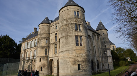
Château de Montataire — local attraction, which is located at All. des Marronniers, 60160 Montataire, France and belongs to the category — castle. Average visitor rating for this place — 4.4 (according to 61 rating, information from open sources and relevant for 2022).
Exact location — Château de Montataire, marked on the map with a red marker.
You can get directions to Château de Montataire on the map from your location.
What else is interesting in Creil? You can see all the sights if you go to the city page.
Coordinates
Château de Montataire, France coordinates in decimal format: latitude — 49.2564649368275, longitude — 2.4428751982134447. When converted to degrees, minutes, seconds Château de Montataire has the following coordinates: 49°15′23.27 north latitude and 2°26′34.35 east longitude.
Nearby cities
The largest cities that are located nearby:
- Boulogne-Billancourt — 49 km
- Amiens — 72 km
- Rouen — 101 km
- Reims — 112 km
- Orléans — 156 km
- Lille — 157 km
- Le Havre — 172 km
- Charleroi
 (Belgium) — 188 km
 - Caen — 206 km
- Namur (Belgium) — 215 km
- Le Mans — 218 km
- Brussels (Belgium) — 219 km
- Eastbourne
 (United Kingdom) — 226 km
 - Tours — 246 km
- Antwerp (Belgium) — 255 km
- Liège (Belgium) — 265 km
- Metz — 268 km
- Gillingham (United Kingdom) — 270 km
- Crawley (United Kingdom) — 276 km
Distance to the capital
Distance to the capital (Paris) is about — 45 km.