
 Maureville
Samoëns
Gréning
Toulouse
Volx
Goudet
Méhoncourt
Saint-Hymer
Pontcarré
Maureville
Samoëns
Gréning
Toulouse
Volx
Goudet
Méhoncourt
Saint-Hymer
Pontcarré
Château de Montvillargenne on the map, Chantilly, France
Photo
Where is located Château de Montvillargenne
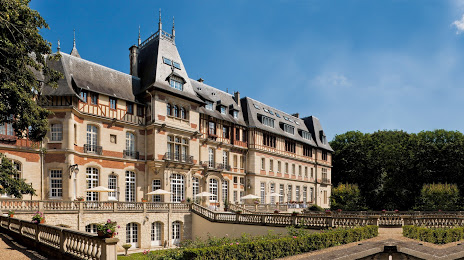
Château de Montvillargenne — local attraction, which is located at 2 Av. François Mathet, 60270 Gouvieux, France and belongs to the category — castle. Average visitor rating for this place — 4.0 (according to 895 ratings, information from open sources and relevant for 2022).
Exact location — Château de Montvillargenne, marked on the map with a red marker.
You can get directions to Château de Montvillargenne on the map from your location.
What else is interesting in Chantilly? You can see all the sights if you go to the city page.
Coordinates
Château de Montvillargenne, France coordinates in decimal format: latitude — 49.1848384754907, longitude — 2.4270472982108675. When converted to degrees, minutes, seconds Château de Montvillargenne has the following coordinates: 49°11′5.42 north latitude and 2°25′37.37 east longitude.
Nearby cities
The largest cities that are located nearby:
- Boulogne-Billancourt — 42 km
- Amiens — 78 km
- Rouen — 102 km
- Reims — 113 km
- Orléans — 149 km
- Lille — 164 km
- Le Havre — 173 km
- Charleroi
 (Belgium) — 194 km
 - Caen — 205 km
- Le Mans — 213 km
- Namur (Belgium) — 220 km
- Brussels (Belgium) — 225 km
- Eastbourne
 (United Kingdom) — 231 km
 - Tours — 240 km
- Antwerp (Belgium) — 261 km
- Metz — 268 km
- Liège (Belgium) — 270 km
- Gillingham (United Kingdom) — 276 km
- Nancy — 277 km
Distance to the capital
Distance to the capital (Paris) is about — 37 km.