
 Maureville
Samoëns
Gréning
Toulouse
Volx
Goudet
Méhoncourt
Saint-Hymer
Pontcarré
Maureville
Samoëns
Gréning
Toulouse
Volx
Goudet
Méhoncourt
Saint-Hymer
Pontcarré
Lac de Viry-Châtillon on the map, Grigny, France
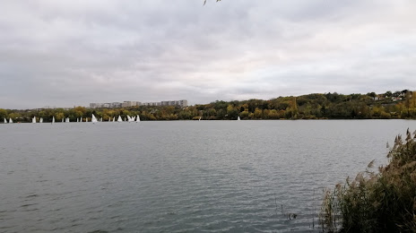
Photo
Where is located Lac de Viry-Châtillon
Lac de Viry-Châtillon — local attraction, which is located at 1.95 km and belongs to the category — -. Average visitor rating for this place — 4.4 (according to 48 ratings, information from open sources and relevant for 2022).
Exact location — Lac de Viry-Châtillon, marked on the map with a red marker.
You can get directions to Lac de Viry-Châtillon on the map from your location.
What else is interesting in Grigny? You can see all the sights if you go to the city page.
Coordinates
Lac de Viry-Châtillon, France coordinates in decimal format: latitude — 48.66793022608325, longitude — 2.3895998862344237. When converted to degrees, minutes, seconds Lac de Viry-Châtillon has the following coordinates: 48°40′4.55 north latitude and 2°23′22.56 east longitude.
Nearby cities
The largest cities that are located nearby:
- Boulogne-Billancourt — 23 km
- Orléans — 90 km
- Rouen — 127 km
- Reims — 136 km
- Amiens — 137 km
- Le Mans — 177 km
- Le Havre — 188 km
- Tours — 189 km
- Caen — 207 km
- Lille — 223 km
- Charleroi
 (Belgium) — 242 km
 - Dijon — 248 km
- Angers — 256 km
- Namur (Belgium) — 266 km
- Eastbourne
 (United Kingdom) — 276 km
 - Nancy — 277 km
- Brussels (Belgium) — 279 km
- Metz — 279 km
- Rennes — 306 km
Distance to the capital
Distance to the capital (Paris) is about — 21 km.