
 Maureville
Samoëns
Gréning
Toulouse
Volx
Goudet
Méhoncourt
Saint-Hymer
Pontcarré
Maureville
Samoëns
Gréning
Toulouse
Volx
Goudet
Méhoncourt
Saint-Hymer
Pontcarré
Église Notre-Dame on the map, Saint-Lô, France
Photo
Where is located Église Notre-Dame
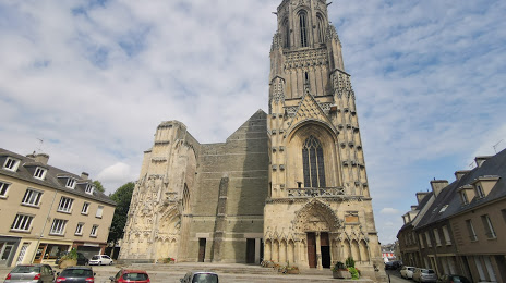
Église Notre-Dame — local attraction, which is located at 2 Rue Carnot, 50000 Saint-Lô, France and belongs to the category — catholic church. Average visitor rating for this place — 4.4 (according to 361 rating, information from open sources and relevant for 2022).
Exact location — Église Notre-Dame, marked on the map with a red marker.
You can get directions to Église Notre-Dame on the map from your location.
What else is interesting in Saint-Lô? You can see all the sights if you go to the city page.
Coordinates
Église Notre-Dame, France coordinates in decimal format: latitude — 49.11550620626451, longitude — -1.0940900017915558. When converted to degrees, minutes, seconds Église Notre-Dame has the following coordinates: 49°6′55.82 north latitude and -1°5′38.72 east longitude.
Nearby cities
The largest cities that are located nearby:
- Caen — 52 km
- Le Havre — 95 km
- Rennes — 119 km
- Le Mans — 155 km
- Rouen — 161 km
- Angers — 185 km
- Bournemouth
 (United Kingdom) — 186 km
 - Portsmouth (United Kingdom) — 188 km
- Southampton (United Kingdom) — 200 km
- Eastbourne (United Kingdom) — 206 km
- Nantes — 213 km
- Crawley (United Kingdom) — 229 km
- Tours — 232 km
- Boulogne-Billancourt — 244 km
- Exeter (United Kingdom) — 247 km
- Amiens — 256 km
- Sutton (United Kingdom) — 256 km
- Reading (United Kingdom) — 259 km
- Orléans — 259 km
Distance to the capital
Distance to the capital (Paris) is about — 253 km.