
 Maureville
Samoëns
Gréning
Toulouse
Volx
Goudet
Méhoncourt
Saint-Hymer
Pontcarré
Maureville
Samoëns
Gréning
Toulouse
Volx
Goudet
Méhoncourt
Saint-Hymer
Pontcarré
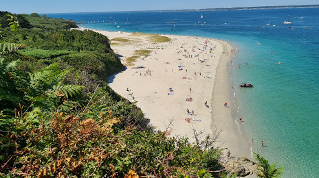
Les Grands Sables on the map, Ploemeur, France
Photo
Where is located Les Grands Sables
Les Grands Sables — local attraction, which is located at no data and belongs to the category — -. Average visitor rating for this place — 4.8 (according to 84 ratings, information from open sources and relevant for 2022).
Exact location — Les Grands Sables, marked on the map with a red marker.
You can get directions to Les Grands Sables on the map from your location.
What else is interesting in Ploemeur? You can see all the sights if you go to the city page.
Coordinates
Les Grands Sables, France coordinates in decimal format: latitude — 47.730024118422975, longitude — -3.448905297722801. When converted to degrees, minutes, seconds Les Grands Sables has the following coordinates: 47°43′48.09 north latitude and -3°26′56.06 east longitude.
Nearby cities
The largest cities that are located nearby:
- Brest — 106 km
- Rennes — 136 km
- Nantes — 152 km
- Angers — 216 km
- Le Mans — 270 km
- Caen — 273 km
- Tours — 310 km
- Le Havre — 320 km
- Exeter
 (United Kingdom) — 330 km
 - Bournemouth (United Kingdom) — 347 km
- Rouen — 376 km
- Portsmouth (United Kingdom) — 378 km
- Southampton (United Kingdom) — 378 km
- Bordeaux — 391 km
- Orléans — 396 km
- Bristol (Great Britain) — 415 km
- Limoges — 418 km
- Eastbourne (United Kingdom) — 424 km
- Boulogne-Billancourt — 430 km
Distance to the capital
Distance to the capital (Paris) is about — 447 km.